
I’m in the home stretch: only 100-ish miles to go until the Mexico/U.S. border, and the end of this wild ride! Along with my trusty trail partner Cheesy Puff, who I’ve been with since day one, we tackle the remainder of the desert, have a gander at a rock shaped like an eagle, get attacked by cholla, encounter an inappropriate cactus, eat some apple pie in Julian, celebrate Halloween on-trail, and get some trail magic from a group of Aussies. The border is in sight, quite literally! Here’s the last dipatch from my SOBO PCT thru-hike!
Day 116: Warner Springs to Dry Gulch, 23 miles
Cheesy Puff and I wake up before the sun is up, breaking camp in the dark and then taking advantage of the indoor plumbing at the Warner Springs Community Center one last time. I take my sink laundered clothes from the clothes line where I left them overnight and surprisingly, they’re dry. Once there’s the first rays of daylight, we fill up on water and head out into the desert.
The day is overcast, bringing with it much cooler weather and comfortable hiking. We cross a dry, desolate prairie, where only dead grass, dusty trail and cow pies exist with us. A fox runs across the field, in between some grazing cattle, breaking up this bleak monotony with a dash of color.

We reach the natural rock formation of Eagle Rock, a favorite visit among thru-hikers and day hikers alike, but it’s literally crawling with about a dozen or so boy scouts. One of the troop leaders notices us, and tells the boys to scram so we can have a photo, and he offers to snap the picture for us. We don’t stop to rest, trying to put in some good miles before the sun decides to burn off this cloud layer and makes things unbearably hot again.

We enter another lovely oak grove, cross a highway and find ourselves at the flowing Barrel Springs. The water is actually clear, spilling from a pipe into a cow trough. Thousands of bees are swarming to get a drink, just like us. We fill up, and then camel-up, resting on a log and eating our second breakfast with coffee.
I’m feeling terribly sluggish, low on energy and aching all over. After only a few more miles past the spring, I have to stop again and have a break, as I feel wobbly in my legs and my hands are shaking. I eat some more food, even though I don’t feel hungry, and make some Gatorade mix. I’m feeling much better after this, and my energy returns almost instantly. Back on track, we surpass the 100 mile mark, followed by the cheeky 99 mile mark, only one of which made it to my camera roll.

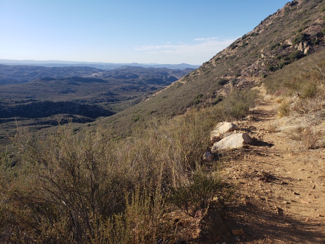
As predicted, the sun comes out and turns our cool day into a sweltering firestorm, and the heat is so stifling I can barely breathe. The trail hugs the hillsides, weaving in and out of gullies and the charred landscape of a past wildfire. A turkey vulture soars overhead.
I round a corner and notice a lump on the bottom of my shoe, and I stop to investigate. It’s a chunk of cholla cactus stuck to the sole, and I try to gingerly pull it out, but end up with several barbed spines stuck in my fingers. I give one a pull, but it’s in there really good, and when I’m on the verge of a panic attack, Cheesy Puff arrives and pulls out a pair of tweezers. She plucks each one out, in single yank that has me on the cusp of tears. She’s efficient though, and has them all out in just a few minutes. “Don’t touch those again, did you learn your lesson?”
I nod.
At a pipe gate, we find the spur trail to a water cache left by some very generous trail angels. It’s out of the way, about a half mile or so down the trail, but well worth the extra trek. We find a few pallets stacked with jugs of water, sitting under tarps. We only take the allotted amount, three liters, and go about eating our dinners in the shade. We’re surrounded by more cholla cactus, so I’m careful not to lean back too much.


With daylight fading, we push off again into the evening. It’s finally cooling down a bit, and the last few miles into camp are easy enough. We make camp in a deep, wide gulch, protected from the wind and just before it’s fully dark. It’s brisk here, and slightly damp from a long forgotten creek. I finish pitching my tent by the light of my headlamp, and settle in for the night.
It’s dead silent.
Day 117: Dry Gulch to Chariot Canyon Road, and a Trip into Julian, 24 miles
We head out early, as we have a trip into the town of Julian ahead, to resupply and claim our free-to-thru-hikers-only slice of apple pie from Mom’s Pies.
We spend the morning winding through the hills, under a repeat of overcast skies and cooler weather. We’re trying to hurry, mostly because we can’t wait to stuff our faces with real food again. I have to stop, however, and take a photo of a rather phallic looking barrel cactus that’s beside the trail, and then text it to some friends back home (priorities).
The trail descends dramatically towards the highway at Scissors Crossing, where there seems to be a steady flow of Sunday traffic out and about. Yet, once we’re there and with our thumbs out, no one is biting. It’s mainly massive RVs passing us by, who of course have plenty of room, but are piloted by retirees who think we’re probably up to no good.

After a while, a pickup truck driven by a local picks us up and takes us into town, dropping us off near the post office. I grab my resupply box, which has a pleasant surprise for us for the upcoming holiday. Afterwards, we walk to the center of Julian and to Mom’s.
Mom’s smells so decadently great when we walk in, like butter and spices and brown sugar, and my gut hurts from the brewing hunger. I order the traditional apple pie, with cinnamon ice cream and a cup of coffee, and Cheese gets the Dutch apple version. It’s so delicious, and I try to savor each bite instead of devouring it in seconds. It’s everything I could have hoped and wanted; a celebration of sugar and fat! We sit for a while longer, drinking coffee, charging our phones and using the WiFi. A group of young Australian guys come in, and sit adjacent to us, inquiring if we’re thru-hikers. We assure them we’re southbounders, and they tell us they were northbounders who came back to get the pie they had originally missed out on and heard so much about. The pie at Mom’s is world famous, after all.
“We’re flying out of LAX in a few days, and we came down to do some trail magic. Maybe we’ll see you further down tomorrow.”
We say goodbye for now, and then make our way over to the Italian restaurant to load up on even more carbs. I power through a dinner salad, some spinach tortellini and my weight in bread and butter, and shovel the leftover pasta into my Talenti jar to take with me (no shame). Cheese takes the remainder of her Spaghetti Bolognese as well.

Once we’re thoroughly full, nearly to the point of vomiting, and Cheesy Puff has bought her resupply from the local grocer, we walk to the edge of town to begin our hitch back to the trail. We know that we have an enormous climb ahead and we need to get back, but what we don’t know is that there’s a frustratingly painful ride down the highway in store for us.
A woman in a white Mercedes picks us up, and the first thing she mentions is that it’s too late in the season to be walking the PCT and we will never make it. This statement is meant to be harsh, and she drives it home with a coy smile.
“We’re southbound, we started at the Canada border and we’re finishing at the Mexico border. We’re almost done.” I explain, but it either falls on deaf ears or she can’t comprehend that people might actually hike the PCT in the opposite direction.
“Mexico? So you’re going down the Baja.” She’s really flying around the corners on the winding road, and we’re clinging to the handles in the car.
“No, we end at the border.”
“Well, you girls shouldn’t be out here alone, you know…”
“We’re not, we’re with each other…”
We’re nearing Scissors Crossing now, and she points to the mountains in the north. “You’re gonna have to climb up that tonight, you know!” She cackles, and I’m gritting my teeth. I glance back to Cheese through the rear view mirror, and she’s sporting a look of contempt.
“No, we came down that. We’re going south.” I point to the other side, and she suddenly slams on the brakes of her car.
“South! SOUTH? Well I’ve only ever dropped off hikers going NORTH, I don’t know where to go!” She’s panicked, as am I. She’s raising her voice. What the hell is going on? How do I get the hell out of this car?
Cheese pipes in from the backseat. “It’s just on the other side of the highway!” She pulls over, skidding across the gravel on the shoulder. “This is fine,” Cheese tells her, and we can’t get out of that car fast enough. We thank her anyway, and quickly walk away, along the edge of the highway and then coming out near a bridge.
Another hiker is sitting under the bridge in the shade, eating handfuls of Halloween Candy. We tell her of our recent, crazy adventure getting back to the trail, have a laugh and then push onward across the desert floor. We cover roughly five miles of walking on a flat, straight trail until we reach the base of the mountains, and at which point we begin our substantial ascent.
Our climb goes on for several miles, gaining a couple thousand feet and crossing more scrubland. Near sundown, we reach the large water tank at Rodriguez Road, but it’s bone dry. It seems as though someone had left the valve open on the spigot, draining it of any and all water, as is evidenced by the damp sand below. We despair, and check Guthooks to see if there’s anything nearby. According to a comment on the app, there’s another tank further down the dirt road, but it’s nearly a mile one way. With nothing left to lose, we start down the road towards what seems like a ranch, nestled in the rolling hills in the distance.
By the time we reach the property of the ranch, it’s getting dark, and the tank proves fruitless. I check a cement cistern that’s up the hill, but it too, is empty. We’ll have to ration what we have, which is a little more than a single liter between us. The next reliable source, according to the water report, is another fifteen miles ahead.
Back on the PCT, it’s pitch black and we continue on by the light of our headlamps. We decide to try and cover as much ground as we can that night, hiking in the cooler temperatures to avoid drinking too much and putting us closer to the next water source. We hike on for another few miles, where the trail joins Chariot Canyon Road for a brief moment. We follow the road, until we see a pull out with the most incredible of miracles: there’s trail magic! Sitting before us, partially hidden in the bushes, is several gallons of water and three cases of soda. We squeal with excitement, cracking open a couple of Sprites and then eating the rest of our leftover pasta.
As this seems to be the best place around to camp and we’re both totally beat after an emotionally exhausting day, we pitch our tents in the pull out. After we’re cozy inside our bags, our friend that we had met at the bridge comes along, and we point out the treasure trove. She grabs a soda, and is on her way again. I quickly fall asleep, feeling far less stressed than just an hour previously.
Day 118: Chariot Canyon Road to Oak Tree Camp, 28 miles
I drink another soda in the morning, as does Cheesy Puff, and we fill up our water before hitting the trail. We start by climbing, a little bitter about the shitty water situation that we were forced into the previous night, but ultimately grateful that a generous and understanding trail angel had our backs when we needed it the most.

The wind picks up midday, and it’s suffocating hot. We press on, through the harsh sun, following an abandoned dirt road that hugs a sheer cliff face. When we come out at a parking area, we find a lovely surprise: it’s the four Australian lads that we had met at Mom’s Pies in Julian, and they’ve kept their word about bringing trail magic! We sit in the dirt, and they pull a cooler out of the trunk of their rental car. They toss us each a can of beer, and tell us to help ourselves to some sandwich fixings. Cheese and I make a couple of turkey sandwiches each, with mustard and fresh avocado, lettuce and tomato; it’s positively dreamy.
We have a healthy break, talking about the economic and social differences between the different parts of the U.S. where Cheesy Puff and I are from, and the land of OZ. They’re kind enough to give us some water before taking off, and a couple of sodas for the road, and then we part ways for the last time.
Cheesy and I keep on trucking, following trail that keeps us at a high elevation with sweeping views of the Laguna Range. We enter pine forest the closer we get to the town of Mount Laguna, and the idea of getting cafe food, or even just a greasy deli hot case burrito, keeps us motivated.

Once we reach a picnic area at a lookout, we cut up from the main trail and walk the road into town, if it can even truly be called a town. The town, or tiny mountain village, is nothing more than a post office, lodge and general store. Further down the road is the Burnt Rancheria Campground, and a cafe with a bar. We get to the store just before closing, and I inquire if the cafe is open. “No, only on weekends these days. But we have things you can microwave, in that freezer over there.” The high school age clerk points to a coffin freezer, and we browse the selection of burritos and hot pockets. I settle on a giant Philly Cheesesteak Hot Pocket, iced coffee and a bag of Cheetos (basically the perfect dinner).
We sit on the big wrap around porch out front, eating our makeshift dinners and discussing how much further we want to go. The store closes up, and suddenly this one horse town is dead. We pack it up and leave, walking the road to the campground, which is closed up and as silent as a graveyard. Even the camp host has exited for the season, but thankfully they’ve left the water spigot on in their site. We fill up our water bottles, with several very thirsty birds dive bombing us in the process. I find an overturned dog bowl near a tool shed, and fill it up for the birds before heading out again.
Back on trail, we follow gentle trail through more oak-pine forest, racing against the darkness of the impending night. We manage to find a nice campsite, beside a dried up creek bed and sheltered beneath some large oak trees. It’s completely dark now, and would likely be silent if it wasn’t for the constant circling of a low flying helicopter. Border Patrol? Most likely. I try to not let it faze me too much, but I pop in my ear buds and listen to soothing music to drown out the grating noise, and fall asleep surprisingly fast.
Day 119: The Tale of the Fox and the Hare, or Oak Tree Camp to Pipe Gate, 24 miles
It’s October 31st, Halloween Day, and we’re less than 40 miles from the border. We’re so close, I can taste it. But first, it’s time to get spooky with our Halloween masks, the ones sent to me in Julian, and have a bit of fun.

We begin our day descending, through Fred Canyon where there’s a trickle of a creek that we can’t access due to the large amount of poison oak that’s surrounding it. Thankfully, we still have a couple of liters of water each. The trail levels out, crossing a flat desert plain where a military helicopter once crashed, leaving behind possible explosives during the disaster. A sign warns us to stay on the trail, and we happily abide. Further on, we find ourselves staring at Mexico in the distance, with only 30 miles of high desert between us and the finish. We have a spur of the moment photo shoot with our creepy Halloween masks on the switchbacks, with the desert as our backdrop.
After a quick snack, we descend towards a highway, with our masks on just in case some passing motorists see us coming down the hill. I truly hope that at least one person caught a fleeting glimpse of the disturbing fox and rabbit duo, only to turn back and see us disappearing beneath the overpass.


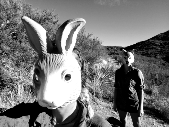


At boulder oaks campground, we stop for an early lunch and fill up on water at the spigots. It appears that the campground is closed, but there seems to be some squatters living here and thoroughly trashing the place. We sit at a picnic table under the shade of an oak tree, drinking cold coffee and filling up on candy and peanut butter tortilla wraps. We finish up round two of our Halloween photo series, and strap the masks to our packs and move on.
By early afternoon, we’re walking on the outskirts of the Lake Morena Community, where roosters are crowing and dogs are barking as we pass by their back yards. We can’t see any evidence of a lake, but we take a seat at the campground anyway and help ourselves to a second lunch, mostly to get out of the midday heat for a while. We no longer need to carry four liters of water, so I toss my dirty bottle, used for filtering, along with my heaps of candy wrappers. I fill up the remaining water bottles with potable water, and make use of the indoor plumbing, and then we climb away from the campground.
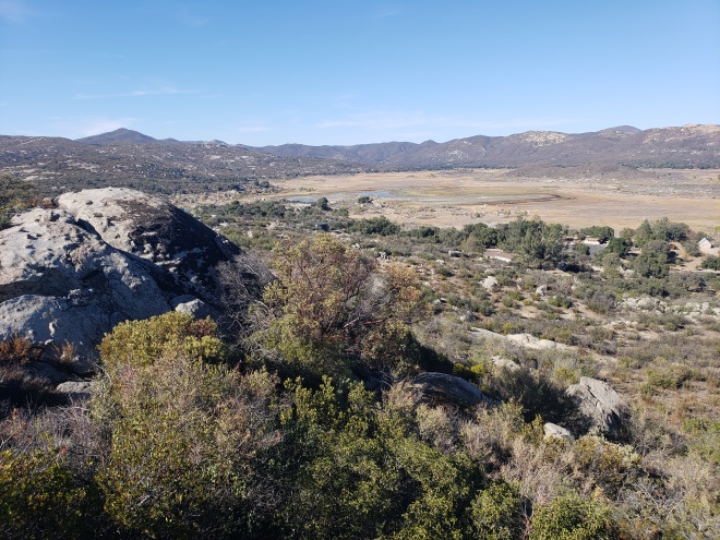
At an outcrop on the side of the trail, we catch a view of the lake finally, and it’s grim. Lake Morena is nearly dried up, at least the area that the campground comes up to. Even a reservoir isn’t sustainable in the Southern California Desert.

We descend into Hauser Creek Canyon, and into the evening. The creek is dry, but the canyon is lush with vegetation and cool enough to enjoy a short break. We climb back out of the canyon, where the trail meets a dirt road, and where a warning sign in Spanish warns against exposure to the extreme elements. More border patrol flies low overhead, and I think they pause to scope us out for a moment before deciding that we’re not worth investigating.
At the top of the climb, the mountains are washed in the soft pink hues of sunset. We pass through a pipe gate, and settle into our very last campsite of our SOBO PCT thru-hike. It’s an emotional, exciting moment, to almost be done. I hang my animal mask over my tent in the nearby manzanita, and Cheesy Puff does the same. “Our spirit animals,” I say, and we laugh. Once the sun has disappeared behind the mountains, I crawl into my bag and set my alarm. We’ll have an early wake up call tomorrow, for the day we finish the Pacific Crest Trail.

Day 120: Pipe Gate to Southern Terminus, 12 miles
Our alarms go off in unison at 3 am, and we grumble as we rise. But we’re still ecstatic, even if it means hiking the first several miles in the dark before sunrise. We quickly break camp, not even taking the time to make coffee.
It’s pitch black when we hit the trail, and we walk under starry skies. The town of Campo twinkles ahead. My headlamp is dim, as I didn’t have any life left on my battery bank to charge it one last time. Just as first light is peaking up over the horizon, it dies.
We’re weaving through the hills, full charge ahead on this cold, windy morning. We cross the railroad tracks, and then a highway, where we catch the first glimpse of the corrugated metal fence that separates the United States from Mexico.

The trail takes us through Campo, first skirting the roadside along the shoulder and then taking us past a border patrol facility, and back into the hills. It’s an odd town, with razor wire surrounding the homes and other properties, an abandoned and ghostly looking correctional youth camp, and dozens of border patrol officers racing up the road on ATVs towards the border.
We reach the one mile marker, ridiculously giddy at how close we are. What a sight, to only be a mile from the finish! In 2016 I thought quite the opposite, as this really was mile one from the beginning; a sick joke for northbound hikers.


As we cross the last mile long stretch of desert, we pick up the pace, especially as we see an American flag whipping in the wind from a tall, dark silhouette. “That’s it!” we scream like a couple of teenagers, and race towards the monument. We give it a good slap once we arrive, followed by a hug, and I take deep breath. I’ve just walked from Canada, over 2600 miles. I’m tired, dirty, sore and beaming from ear to ear. How have I managed to do this a second time? And even faster than the time before! How can walking such a long distance, with such a small amount of stuff, make someone feel so whole?
It took us exactly four months to get here.


The non-climactic ending
Naturally, the terminus is out in the middle of nowhere, along the Mexico border, and there’s no one around to pick us up. I’ve made arrangements for a ride, but they won’t be arriving until the next day. Cheesy Puff and I backtrack the 1.5 miles to Campo, where we find a convenience store across from the bus stop. From there, we’ll take the bus back to Lake Morena, where we’ll camp for the night.
At the store, I buy a sandwich, a bag of chips and a large ice tea. We sit on the curb outside, eating and waiting. After several minutes, a car pulls over, and a nice young man donning a PCT hat offers us a ride. We gladly accept, and he drives us all the way to Lake Morena.
At the campground, we pay the $5 fee for the hiker site, and then immediately go down the road to the Malt Shop for some lunch. I’m hesitant to stuff my body full of greasy food. I’m not going to be hiking long days anymore, after all. But my hiker hunger overcomes me, and I order up a root beer float and meatball sandwich, complete with a plate full of fries. After lunch, we hang around a bit, using the WiFi and buying some nice smelling toiletries to use in the coin-op showers later on.
I pump five dollars worth of quarters into the shower, determined to get a proper, twenty-minute shower and rinse all the grime off of my body once and for all. I bought a full bottle of shampoo at the Malt Shop, and it’s doubling as a body wash as well. Cheese has given me a loofah out of the three pack she’s purchased, and we’re passing the shampoo bottle back and forth over the stall barriers. Naturally, we’re both drinking shower beers to celebrate our victory. I scrub away all the layers of dirt and sweat that’s built up on my legs, and lather up my greasy hair. The hot water soothes my tender-sore muscles, and turns black beneath me. Within minutes, no trace of the trail is left on my body, and has rinsed down the drain. I change into my sleep clothes, the cleanest items that I have on hand, and wash all of my hiking clothes by hand in the sink.
Back at camp, we hang our laundry and continue to chip away at a six-pack, and once it starts getting dark, we retire to our tents. I’ve downloaded a Netflix movie, and I’m content laying and watching that. Cheese has given me her leftover guacamole and chips, and I’m happily snacking away.
I fall asleep early, eagerly anticipating my ride out of here the next day, and finally seeing my family after four long months. It’s been a wild, long, emotional, physically difficult journey, and I’m ready to go home.

SOBO Pacific Crest Trail Thru-Hike; July 5th – November 1st, 2018
Signing out,
-Artemis

Best wishes for your further endeavors, thank you for your insights into the logistics and preparation for long distance hiking, and for supporting your narrative so well with your photographic talent.
LikeLike
Thank you, Stephen, for your support and donation to my campaign with AFSP National! Good luck on your future thru-hike of the PCT, and if you choose to journal about it on this platform or any other, please let me know so I can follow along. Cheers!
LikeLike
Thank you for this wonderful report.I enjoyed every page!
LikeLike
Thank you for following along, Klaus!
LikeLike
Awesome story. A great ending to a great journey. Well done and all the best for the AZT
LikeLike
Thank you so much!
LikeLiked by 1 person
Love your writing!
LikeLike