
Since I’ve returned home from finishing my southbound thru-hike of the Pacific Crest Trail, several of my readers have reached out asking what the first few hundred miles will be like from the Northern Terminus at the Canadian border and through the state of Washington. How snowy will it be? What’s the best time to start from Harts Pass? Will I need extra snow gear? Your questions, answered here, from a Washington local and two-time PCT thru-hiker.

I want to start off by saying thank you to everyone who has reached out to me over the last several weeks, asking me about what to expect in regards to trail conditions in Washington State on a SOBO journey of the PCT. This post is by no means a way of me saying ‘back off with the emails,’ because I honestly love hearing from all of you and giving advice when I can! If anyone has any further questions, I’m still 100% here to help, and you can contact me via email or leave a comment below.
I’m also continuing my fundraising efforts with the American Foundation for Suicide Prevention this year on my 2400 miles of long distance trails in 2019, so if you like what you’re reading here or any of my other posts, please donate to my campaign.
I based this post off of the most common questions that I get asked about southbound thru-hiking the PCT, which takes place in the first 500-ish miles from the border, through Washington State. This includes WA sections (in southbound order) L, K, J, I and H. You can download or print out the maps for free on Halfmile.
For information about resupply strategy in Washington, please see my post about SOBO resupply. (PDF).
For a comparison between NOBO and SOBO thru-hiking, read my post on the subject here.
Will There Be Snow? How Much Should I Prepare For?
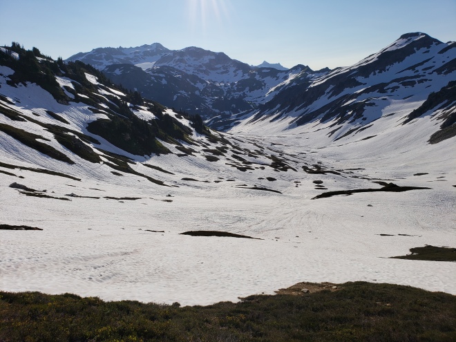
Yes, there is likely going to be snow. The Cascade Range gets hammered with several feet of snow every winter thanks to storms coming in from the Gulf of Alaska, and strengthening over the Pacific Ocean as the Jet Stream pushes systems inland. Even in drought years, there is going to be some snow pack in the higher elevations and in some of the passes. This means you will be traversing snow over Cutthroat, Fire Creek and Indian Passes, just to name a few. The snow in these areas won’t be gone until mid to late July.
Preparing for the snow pack depends on how much there is going to be. If your start date is set in stone, then you may have to pack extra gear during a big snow year. While NOBO hikers have to abide by the start dates on their permits due to the large crowds leaving the Southern Terminus, southbounders have a bit more flexibility. Initially, when applying for your permit, you’ll have to provide a start and end date for your adventure; be sure to give yourself a lot of room! I started on July 5th, a full three weeks after the date on my permit. But since I live in Washington, it was more convenient for me to wait it out.
As far as the gear you may want to consider, an ice axe and microspikes will come in handy if there is still a lot of snow. In addition, you may want to use a route finding app such as Halfmile’s PCT (free) or Guthook’s PCT ($24.99, recommended). Learn how to use an ice axe in advance, and be comfortable with self arresting if need be.

Do I Need to Take a Mountaineering Course?
While having mountaineering skills is never a bad thing, in my opinion you won’t need to take a professional course for hiking the PCT. Unless you plan on starting early, then recognizing avalanche dangers and using an ice axe are a must (see above). The most elevation gains along the entire trail are in Washington, even when compared to the High Sierra. The terrain is rugged and remote.
I started the trail with an ice axe, but found that I didn’t need it at any point. Trekking poles were sufficient, and I walked the entire length of the state in trail running shoes and NOT stiff hiking boots.
Read my original gear list for the PCT here.
To read my post trail gear review, click here.

Just How Intense Is the Terrain?
Washington has an average daily elevation gain of around 5000 feet. That’s pretty intense, and since you’re a southbounder, you’ll be starting your thru-hike with arguably the most difficult terrain on the entire PCT. I found it more difficult than the High Sierra, even with its crazy 10,000+ elevations and thin air.
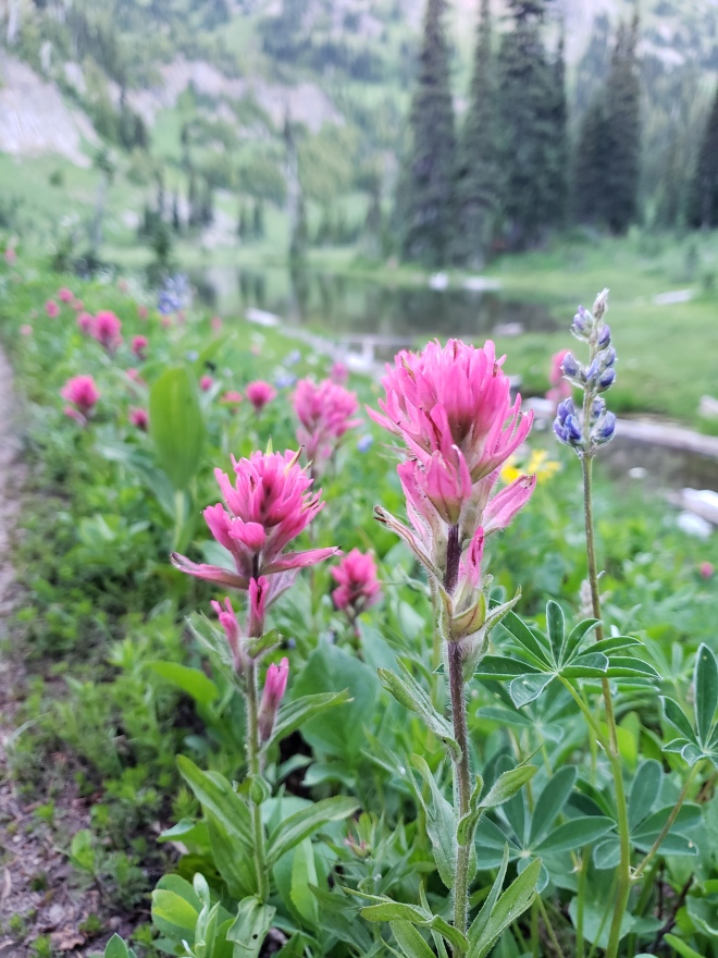
These gains are worth it, however, and you’ll be rewarded daily with some of the most stunning scenery along the entire trail: craggy peaks, stratovolcanoes, old growth forests, wildflower filled sub-alpine meadows, blue-green lakes, glaciers and rushing waterfalls.
When is the Best Time to Start?
I recommend starting two weeks after the USDA Snotel says that Harts Pass is at 0″ for snow pack. This gives some leeway for letting the snow melt out of the higher elevations more, and makes for finding the trail much easier. Also worth noting, the volunteer rangers at the Harts Pass Guard Station won’t be there until there’s zero snow pack, and they provide an opportunity to cache food while you’re doing your 60 mile round trip border tag. If you start before then, you’ll either have to do a long food carry until you reach Stehekin, or get off back at Harts Pass and try to snag a ride into the small village of Mazama for resupply. The latter could be an extremely difficult situation, as the precarious road over Harts Pass is only a gravel forest service road, and not heavily trafficked. Getting back can be challenging, too.

Can I Enter the United States from Canada via the PCT?
No, and don’t even try it. It’s illegal, and if you’re caught, you’re looking at spending time in jail. Canada is gracious enough to allow hikers to apply for an entry permit and cross the border on the trail. The U.S. does not reciprocate this in any way or form, and I’m always surprised by the amount of people on PCT forums who just assume this is the case and are caught off guard when they’re informed otherwise.
Can you enter Canada as a SOBO hiker on route for your border tag, then go around and get back on trail at Harts Pass? Yes, you certainly can. This option should be arranged well ahead of time though, including having your entry permit in hand, a valid passport and a ride back. I very highly doubt hitching from Manning Park and across the border at an official entry point will be easy, as motorists who are about to go through a customs checkpoint probably don’t want a complete stranger in their car for that process.
The PCTA has a entire page dedicated to information about crossing the Canada/U.S. border.

How Cold Does It Get At Night? What About the Temperatures During the Day?
It likely won’t be that cold at night, even in areas above 5000 feet. I did just fine with a bag rated at 15 degrees (F), and I’m a cold sleeper. In fact, I often slept with it unzipped because I was too warm.
Daytime will likely be sunny for the most part, and sometimes downright hot. Protect your skin from sunburn, especially when on the snow. And if you choose to go swimming in one of the many lakes or rivers, please rinse off your sunscreen away from the water source so as not to contaminate it with chemicals.
Washington is known for its rain, and a weather front could move in at any time. However, our summers are quite pleasant and often times fairly dry.

Should I Be Concerned About River Crossings?
Yes. In fact, this one tops my list of concerns more than snow travel. With Washington entering the summer season and the warmer temperatures melting all the snow out, rivers and creeks become raging torrents. Here are a couple of examples of what I encountered:
- In the Glacier Peak Wilderness, my friends and I found ourselves trying to ford a silty, swollen creek midday. This creek was coming down hard off of Glacier Peak herself, and the milky water made it impossible to see where we were stepping. At first, we attempted to cross downstream on a log, but that proved too slippery. We eventually found a less swift point to cross, but we had to bushwhack our way there. We forded with our shoes on, facing the current and at a very slow pace, making sure that our footing was solid.
- After leaving Stevens Pass, my group of three had thought that we left most of the snow and scary creek fords behind us. However, at a camp near Hyas Lake, we met some weekend warriors who warned us of a sketchy crossing just a few miles ahead. The next morning, we packed up and left early so we could attempt the ford when the creek wasn’t swollen from the heat of the day melting out the snow. When we arrived, I was faced with one of the most challenging creeks I’d ever seen. Again, the water was silty, and incredibly forceful. I went in first to test the water level, and sunk in past my waist. The current was so strong, and I was too scared to take another step in fear that I might be swept away. My two partners and I concocted a plan, gripping onto one another, with me entering first, the tallest partner going second, and with the third swinging around to the opposite bank (sort of a daisy chain method). It worked, but just barely. Once across, we sat along the bank of the creek, trying to catch our breath after facing our mortality.
Please be cautious when fording creeks, as this poses the most danger anywhere on the PCT. Cross creeks using trekking poles, and never take your footwear off because you want to avoid getting them wet. Your shoes will already be wet from traversing snow. Trust me, you’ll need the traction. If you can ford using a buddy, do so! Try to cross early in the mornings, despite the icy temperatures, and before the creeks swell with snow melt. You’ll warm up and dry out once you get moving again.

Are Campsites Easy to Come By?
Yes and no: When using the Guthook’s app or Halfmile maps, each one of these publications mentions various campsites along the trail. They tend to fill up fairly quickly, especially on weekends and the closer you are to trailheads, and you can count on never camping alone. Imagine my surprise when my two mates and I settled into a spot described on Guthook’s as ‘having enough room for three tents’, early in the evening, and then waking up to five additional tents crammed into the same area. Yikes.
Campsites along the PCT corridor come at a premium at the start of thru-hiker season, as many of the spots along the way are still under snow or flooded out. On a few occasions, my friends and I had to pitch our shelters in areas where the ground was pretty saturated. A Tyvek ground sheet came in handy for keeping the floor of my shelter dry. Polycro works too.

Is the Trail Well Marked?
The trail is very well-marked most of the time, although more so in the opposite direction for NOBO hikers. The exception would be in the passes, where maps and a navigational app are indispensable for route finding. In reality, though, getting lost really isn’t a concern and you shouldn’t fret too much about it. Look for the official PCT trail markers, offen nailed to trees, and wooden signs at trail junctions. The PCT is often labeled as ‘no. 2000’ on sign posts, in keeping up with number labels for trails.

How Bad Will the Mosquitoes Be?
I think this changes from year to year, based on the level of standing water left from snow melt, but I didn’t really struggle with swarms of the bloody thirsty savages until right before I got to Stevens Pass. From there, you enter the Alpine Lakes Wilderness, and the name is very telling: lakes are mosquito breeding habitats, and there’s a plethora of them in this wilderness area.
After Snoqualmie Pass, they weren’t much of an issue until reaching White Pass, and they faded after the Goat Rocks Wilderness. In any case, a bug net for your face is helpful and lightweight.

How Remote is the PCT in Washington? Is It Difficult to Resupply?
The population density in Washington is mostly contained in the Seattle-Tacoma metropolitan area (with a few exceptions of course), and once you head east towards the mountains it becomes shockingly rural. Visitors from out of state are nearly always surprised at how little they have to travel from the city center to find themselves in true wilderness.
The entire PCT corridor through Washington seems fairly remote, when looking at resupply points and comparing it to say, California (where there’s multiple options). Hitching into towns can be difficult at times because of this, but locals are well aware of the trail and are likely to pick you up if they see you. If you’re planning on buying your resupply instead of mailing it, be prepared for a limited selection in convenience store type settings, and with inflated prices.

For example: the small store in Stehekin that’s attached to the lodge may or may not have a good variety to choose from. On my SOBO journey in 2018, they had Clif Bars, a lot of candy, ramen packets and Knorr Sides. All of these things were about twice the price of a supermarket. In 2016, the store was bare bones. The village is only accessed by float plane or ferry across Lake Chelan (or hiking in via the PCT), so it all just depends on when they’re getting their next supply run. If you arrive too early, outside of the tourist season, you run the risk of not being able to get what you need. Thankfully there is a post office, and they have a great organized system in place for when they get inundated with resupply boxes.
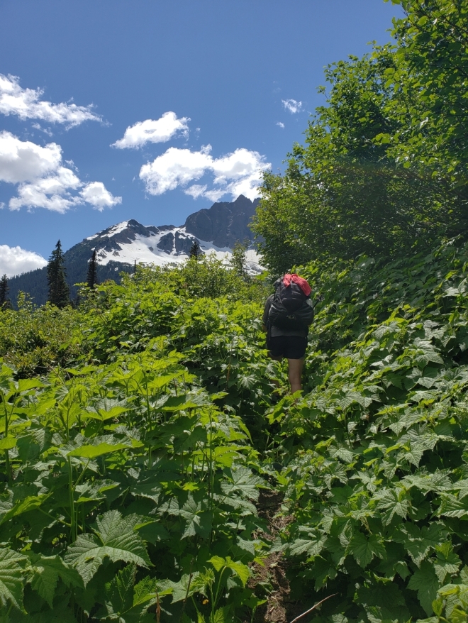
As far as remoteness of terrain goes, there are areas in the North Cascades and Glacier Peak Wilderness where trail crews haven’t worked in years. This is apparent by how overgrown some stretches are, and how many blow downs you’ll be crawling over. With over 100-mile sections without civilization, it’s hard to organize work parties who can spend weeks on end out in the middle of nowhere improving the trail. Long story short, it’s a logistical nightmare for them.
Will There Ever Be An Issue Getting Water Anywhere In Washington?
Quite possibly, but not until you reach the southern end of the state. The closer you get to the Columbia River, and Oregon for that matter, you’ll notice a change in scenery. The dense, damp forests of fir trees give way to scrawny pine and the occasional oak grove, and the trail becomes noticeably more dusty and dry. Your water carries will become a bit longer in between sources, and you’ll find yourself relying on trickling springs and mucky ground seeps, instead of the clear creeks you were once accustomed to. Pay special attention to the PCT water report (you can download it for free here) or the comments on the Guthook’s app.


Should I Be Worried About Bears and Mountain Lions?
For the most part, no. While you should always be ‘bear aware’ and practice proper food storage, black bears in the Pacific Northwest are timid of people and usually keep their distance. From my own experience, problem bears (I hate this term because it’s always problem humans) are usually found in rural neighborhoods where people keep their trash bins outside and accessible to wildlife. I’ve never carried an bear canister at any point on the PCT through Washington, and I’ve never had a problem with bears in my campsite.
Just a few weeks prior to my southbound thru-hike, a mountain biker was killed by a cougar on a forest service road in my hometown. This caused a frenzy in the local and national media, and some of my friends and colleagues were warning me against going hiking solo, and even sending me links to article concerning the matter. This was the only known case in Washington of a human being killed by a mountain lion, and not a single PCT hiker has ever even been harmed by these big cats in the history of the trail. Not a single PCT hiker has been killed by a bear either. Wildlife officers kept explaining that this attack was extremely rare, and while I knew this and wasn’t concerned, it fell on deaf ears with the general public. Don’t let fear mongering deter you; the media is really good at creating sensationalized events.
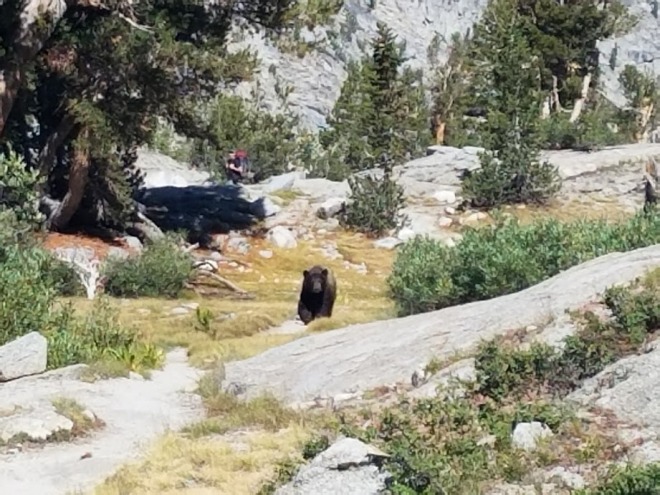
While a cougar and/or bear sighting is could very well happen, I don’t think it’s much to worry about. Keep a tidy camp and practice proper food storage to keep bears away at night. Talk loudly or sing while hiking so you don’t startle them if you do happen to see one on the trail. Give them space if there is an encounter, and never get in between a mama and her cubs. Also worth noting: mountain lions are rather nocturnal creatures, and tend to stalk their prey at night, or when it’s dark.
Grizzly bears have made a comeback to Washington, although the population is tiny and mostly located in the Okanogan region in the northeast corner of the state.
And while we’re on the subject of comebacks, wolves have also made a triumphant return to the wilds of the west coast, including Washington. Wolves are incredibly shy creatures, and again, nothing to be overly concerned about.
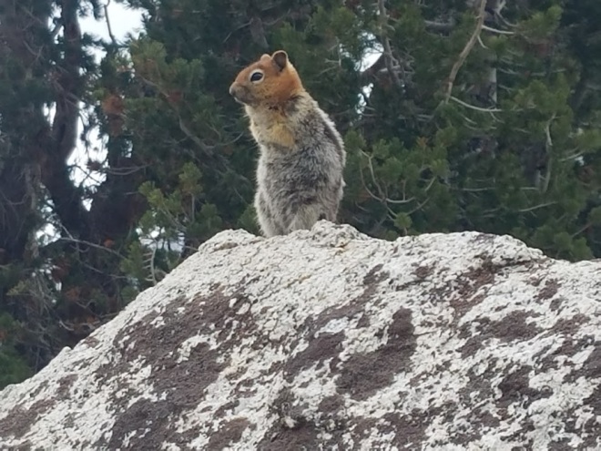
One thing that Washington has no shortage of is mice, and that has always been my number one concern when backpacking in my home state. There’s literally thousands of them, skirting the edges of your campsite and waiting for you to drop a morsel of food or go to bed so they can scour the area for crumbs. If you leave any food inside of your pack, prepare to have a hole chewed through it.
Recently, hantavirus and bubonic plague (seriously) has made their way to the rodent population in the Pacific Northwest. Hantavirus is scary, and deadly. It’s transmitted through rodent feces and urine, and goes airborne when those tiny poop pellets or urine dries up. Imagine that unknowingly sitting in your pack, and you’re inhaling it every time you reach inside for a snack. Thankfully, hantavirus is killed under UV light, so you won’t have to worry about any turds scattered around your campsite. You should definitely take food storage into consideration, and maybe invest in a Ursack, so mice and other rodents like chipmunks and squirrels, can’t chew through your food bag.
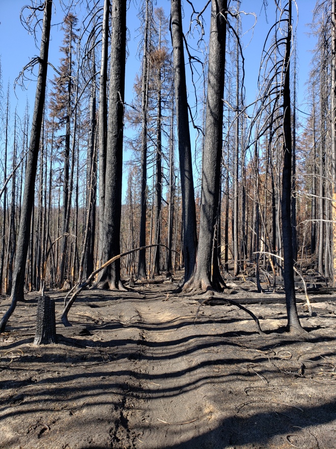
Is There a Wildfire Risk?
Yes, especially in recent years. As a SOBO hiker, encountering a wildfire will be unlikely because of the snow melt. However, the risk is still there, especially in drought years and if you have a later start. Wildfire season typically starts in August, when things begin to dry out, and extends into September or until the first major rainfall of autumn.
The PCT Association and the Forest Service are really great at communication when a fire presents itself, and they’ll usually have a detour in effect. If there’s not detour, hitching or finding other transportation around will be your only option. If a wildfire starts in your proximity, know how to get out and protect yourself. I’m not going to offer any advice on here about escaping fires, because quite frankly, it’s a serious subject and I’m not an expert on the situation. Do your research.
Take a Deep Breath, You’ll Be Fine
I know first hand how pre-trail jitters feel; thru-hiking is intimidating! You’re leaving all the comforts of your home and family to go traipsing through the wilderness for months on end. That’s not a decision you make on a whim, at least I hope not.
Researching and getting a feel for terrain is the best thing you can do to prepare, just don’t nail down a strict itinerary that you feel you need to abide by. The trail will throw some surprises your way, but be mentally prepared to cross that bridge when you get there. And just know, you’re not alone and there will be other hikers there to support you if needed. You’re stronger than you may realize, and the trail will only confirm it.
As I mentioned at the start of this post, I’m still here to answer questions, no matter how random you think they are. Better to ask for help when you need it…
Enjoy yourself out there and happy trails,
-Artemis
Further Reading That May Be of Interest
- What I wore on my SOBO PCT thru-hike
- My efforts to raise awareness for mental health through long distance hiking
- Resupply Notes for SOBO PCT Hikers (PDF)
- PCT Association page for southbounders
- Guthook’s PCT app
- PCT SOBO Trail Journal: Harts Pass to Stehekin
- PCT SOBO Trail Journal: Stehekin to Stevens Pass
- My Budget for the PCT


Once again, well done!
Sent from my iPhone
>
LikeLike
Hi Artemis, I’ve enjoyed your blog. I’m leaving Harts Pass on 6/30/19 for my sobo thruhike. I live in Idaho now but used to live in Snoqualmie. Anyways, when did the Harts Pass snotel hit zero in 2018? I’m curious to know how long after it hit zero you experienced the conditions you describe in the blog, with your 7/5 start). It is a pretty low snow year (the snotel says 17 inches today) and I’m hoping I can leave my axe and spikes at home for a 6/30 start. Thanks!
LikeLike
Hi Paul, congrats on your upcoming thru-hike! I started about 10 days after the snotel reported at 0″ at Harts Pass. I took my ice axe & microspikes, but didn’t really need them.
LikeLike
I just stumbled across your blog and thanks so much for all the info! I started my NoBo thruhike last year and will be back on trail next week, hiking south from the canadian border until Elk Lake..I cannot wait to be back on trail, I miss it so much 🙂
LikeLike
Artemis, you have put a lot of thought and energy into this web site. That is no easy task to put everything together so comprehensively, thank you so much for doing this. I’m a dad to a daughter and grandpa to a grand daughter and I really like examples of strong minded independent women. I’m on Vancouver Island and while it’s not looking too hopeful at this point that the PCT or our border is going to open up I’m still going through the planning process in case things turn around. I backpack alone so that along with my age I try to reduce risk when possible. Given your expertise with thru-hiking and Washington state conditions would there be a time and diminished snow melt advantage to starting NOBO at the Oregon/Wash border earlier in June thereby hitting some of the more snow packed areas in July perhaps later than what would be a typical start date from Harts, then flipping back to Oregon and continuing on SOBO. Or would it make sense to start somewhere in Oregon in May NOBO before flipping? Or, does none of what I’m thinking make any sense?
Thanks again, take care in these strange times.
Frank
LikeLike
Hi Frank! Thanks for the kind comment:)
I think starting anywhere in WA or Oregon that early would see you running into difficult areas with a good amount of snowpack, unfortunately. If you started NOBO from Cascade Locks, then you’d have the Goat Rocks/Knife’s Edge to contend with, which typically has snow well into late July (unless it’s a low year, which really hasn’t been the case lately).
Oregon will also have quite a lot of snow through May & June. Just this past July, I did a section through the Mount Jefferson Wilderness & had to deal with quite a bit of snow & route finding.
I feel July is a better start time for most areas in the PNW, as it makes the trail and the several passes more navigable.
I hope this answers your questions; feel free to reach out again via the comment section here or by email (contact link). I’m helping to help!
LikeLike