
In the Spring of 2016, I set off from the Southern Terminus on the Mexico/U.S. border in Campo, California, with not a clue in the world with what lied ahead on the 2,650 mile Pacific Crest Trail. I learned some valuable lessons about the endurance of thru-hiking, trail culture, and most importantly, myself. I finished 5.5 months later, in Manning Park, Canada. In 2018, I did it all over again, only this time I went southbound. Armed with extensive insider information regarding the trail, I had a better idea of what to expect. Why do it again? I still don’t know. Why does anybody do anything? Here’s what I learned on both of my thru-hikes, and my interpretations of the hikertrash scene.

No. 1: Traversing the High Sierra is Far Different Depending on Your Direction
NOBO and SOBO hikers face a stark contrast in trail conditions through the Sierra because they are hiking during different times of the year. Here’s my takeaway.
NOBO
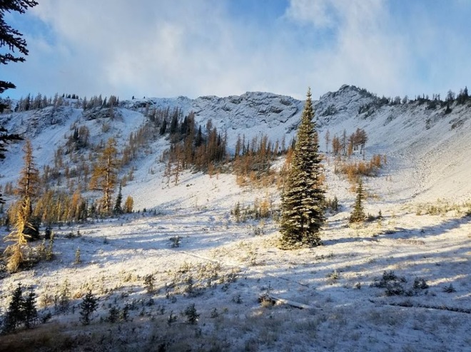
I left Kennedy Meadows on June 3rd, 2016, and suddenly I found myself traversing the rugged, high elevations in the shoulder season. I’d often be wading in knee-deep in snow, and then fording waist deep creeks swollen with snow melt, all in one day, everyday for about a month. My feet were constantly wet and I had borderline trench foot. Some of the passes were down right terrifying to be going over, still covered beneath several inches of melting snow that could give way in an avalanche at any moment.
I also encountered a late season snow storm going over Glen Pass, in which I had to use my ice axe to self arrest. I used my ice axe a couple more times after that, the most notable being when I was descending from the Emigrant Wilderness towards Sonora Pass, on slushy snow and loose scree. A day hiker who had gone down ahead of me was being helivac rescued out due to a fall resulting in a head injury.
To make things worse, the mosquitoes were horrendous, with a black cloud of the little bastards swarming around my head as I hiked. This made taking breaks difficult, as I couldn’t very well eat with a bug net covering my face. I often would rush to set up my tent in the evenings, and eat dinner inside the safety of my shelter. In bear country. Yikes.
The silver lining to all of this, is the wildflowers were blooming and colorful, the marmots were coming out of their winter holes, and the abundance of water meant I never had to carry more than a single liter at a time.

SOBO
The High Sierra was nothing short of pure joy to be walking through this time of the year: we left Sonora Pass on September 16th, and got to Kennedy Meadows (south) on October 1st. The weather was sunshine perfection the entire way, but often below freezing temperatures at night. Often times, my companion and I would wake up with a layer of ice on our tents. When I got to Independence, I thankfully had my sleeping bag liner waiting inside of a resupply box for me (I had it sent from home), which added some much-needed heat to my sleep system. We beat the first snow of the season by about ten days.
Resupply was a bit of a problem, due to it being late in the season and most of the resorts were closing up for the rest of the year (more on that below). After Forester Pass, it was noticeably drier than the rest of this section, and we found ourselves worrying about our next water sources in the fifty odd miles from Chicken Spring Lake to Kennedy Meadows. It turned out to be pretty dry, with our most reliable water being the Kern River.
Final Thoughts
I disliked the Sierra section the first time around, or disliked the way I felt, due to the treacherous conditions. I feared for my life on more than one occasion, which really isn’t a great feeling. I’m going to say that southbound wins this round for me, as I’ll take cold nights over sloppy snow and mosquito hell any day of the week.

No 2: Resupply Locations and Trail Angels Cater to the NOBO Crowd
Northbounders have an advantage over southbounders when it comes to getting trail magic and resupply. Here’s why.
NOBO
Within the first 100 miles of my NOBO trek, I got trail magic four times: a man named Ed was waiting at Scissors Crossing to give hikers rides into Julian, where I got a slice of decadent apple pie from Mom’s Pies, and a lovely woman named Carmen made me a breakfast burrito that was bigger than my head. All of this was free. And just before I reached Warner Springs, two gentlemen that I met at Eagle Rock gave me cold ice tea, a frozen Snickers bar and some sunscreen. Most of the trail was like this, save for the last half of Washington, with a plethora of trail angels surprising hikers with treats to keep us motivated, and restoring our once fading faith in humanity.

Resupply was never an issue, with all businesses in the trail towns open and stocked with the goods that hikers need, such as ramen, candy, Clif Bars, instant rice, travel-sized toothpaste, and ice cream. Even in remote areas, such as the Sierra, the resorts catered to the hikers, offering a decent selection of resupply options in their tiny shops, accepting packages for a fee, and operating coin-op showers and laundry facilities. At Reds Meadow, there’s a shuttle running into Mammoth Lakes every couple of hours, every day from late June through the Labor Day weekend.
SOBO
I didn’t get my first trail magic on my southbound thru-hike until somewhere around mile 450, in southern Washington. It was at a road crossing, where a nice couple had set up a grill to cook breakfast for passing hikers. However, it was obvious it was meant for northbounders: my trail family and I had crossed the road, saw a sign facing opposite as us that read ‘trail magic’, and turned on our heels to go back. The trail angels were shocked to learn that people actually head in the opposite direction, and went about making a sign for the rest of the SOBOs to see as we trickled down the trail.
In northern California (and even further south, if I’m being honest), we were often mistaken for northbound hikers in town, and then accused of being too slow and late in the season. Once we insisted we were heading south to Mexico, we were again met with shock and sometimes even disbelief. A man in Independence, after finding out we were thru-hikers, declared that we’d never finish the trail because he assumed we were heading towards Canada, and it was late in the season. And near Julian, a woman giving me and my friend a ride, panicked when she didn’t know where to drop us off back at the trail because “I only drop off hikers going north!” When we assured her it was in the same spot, just on the other side of the road, she grew agitated.

The Sierra was a logistical nightmare compared to NOBO, with southbound hikers rushing to get to resupply points before they shut for the year. I made it to my first parcel pickup, Tuolumne Meadows, only two days before it closed for the winter. Reds Meadow, who I planned on buying my resupply from at the general store, was nearly wiped out of food. Since it was well past Labor Day weekend and mid-week, the bus into Mammoth wasn’t running any longer and I had to make do with the very limited selection. Just past Reds Meadow, Vermilion Valley Resort’s resupply box holding fee jumped from its regular price of $28 to over $55 as they neared closure, and Muir Trail Ranch closed a few days earlier than expected. Thankfully, Kennedy Meadows was still going strong, although they ran out of burgers at the grill while I was there.
Final Thoughts
Why do northbounders have an advantage here? Because there’s more of them, and that’s the only reason. According to the PCT Association, 90% of thru-hikers went northbound, and from my experience, it showed. The trail going north was crowded, and on more than one occasion in the desert, I had to find a new campsite due to the one I had my heart set on being packed full once I arrived in the evening. The denseness of the NOBO crowd lessened the further north I progressed, and the same goes for SOBO; after the Sierra, my companion and I rarely saw another thru-hiker as we traversed the desert sections.
Going south, I knew from the beginning that I’d have to hit the ground running on the difficult North Cascade terrain in order to get through the Sierra before everything closed. This meant doing twenty-mile days right out of the gate, and bumping up my mileage through Oregon and NorCal (I did thirty plus mile days in Oregon, but this is extreme and not totally necessary). I was also racing the first snow in the Sierra section, trekking through in mid to late September, and had to keep my mileage high to get to Kennedy Meadows before then.
In my opinion, timing is everything going south. Northbound allows you a more leisurely pace. In 2016, it took me 5.5 months to reach Canada, while last year it took me exactly four months on my SOBO thru-hike.
No. 3: Cliques & Competitive Behavior Happen, Either Way
Some hikers like to pretend this doesn’t exist, and they may be sharpening their pitchforks as they read this. Most people in the hikertrash community are incredible, respectful people, but I think this behavior needs to be addressed nonetheless, and I often get asked about trail culture. Here’s what I saw.
NOBO
After hiking through the entire desert as a solo hiker, I ran into this guy I knew at Kennedy Meadows who questioned why I was still hiking by myself, and basically called me socially inept. I had first met him near Warner Springs, and he had asked me how many miles I had done so far that day. I would go on to learn that this is a way of some people measuring you up, comparing themselves to you and making themselves feel more adequate. I also saw this same guy berating a woman in his trail family while at Kennedy Meadows, for not liking a certain flavor of Pop Tart. I later caught up to him at a mountain pass in the Sierra, hiking alone, and he wouldn’t make eye contact with me when I passed. Maybe don’t be like this guy.
I got used to walking alone in the beginning, and made friends in passing as I leap-frogged various people throughout the day. Sometimes we’d take breaks together, squished together in a small patch of shade; and sometimes we’d camp together later on in the evening. But we did our own thing, not allowing a group culture to dominate our daily schedules. If we saw one another again down the line, great. If not, no big deal, we may leave a friendly note to one another in the trail registers.
Now, I’m not saying all trail families are horrible, because they’re not, and some people just work together from the get-go (see below). I did eventually find my ‘trail fam’ on my NOBO hike, it just took me until slightly past the halfway point. There’s nothing wrong with this, and don’t let anyone try to make you feel bad about it. There was a buddy of mine that insisted on walking alone all day, and camping alone at night; this was his preference and totally respectable. It’s not high school, it’s a trail. Hike your own hike.
SOBO
I set out this time with the same expectations of traveling alone for most of the way, and I had come to terms with that style of hiking. I knew that southbound was less crowded, so I wasn’t sure how many people I’d meet along the way. I did, however, provide a ride up to Harts Pass to two other hikers since I live in Washington. This allowed me to get to know at least a couple more potential thru-hikers before we had started the trail. At the trailhead, however, I met another hiker called Cheesy Puff, who I would go on to hike the entire trail with, from start to finish. This is incredibly rare, and no one should count on this happening. Cheesy Puff and I clicked right away: we hiked the same pace, doing the same desired mileage, had a very similar sense of humor and shared the same moral beliefs. Another hiker joined us from Stehekin to Seiad Valley, and then decided he wanted to hike alone from there. No worries.
Cliques did form with the southbounders, but more noticeably, there was less judgement towards those who chose to hike alone. In fact, there were far more ‘lone wolf’ hikers in comparison to my time going northbound, with no shit talking regarding it.

Competitiveness was still very much alive among the SOBO crowd, much in the same way that it is with the NOBOs. “How far have you come today? I’ve already done 25 miles…I think I’ll do another 10 before camp. Tomorrow, I’m going to push for a forty mile day.”
I’m happy that you’re an exceptional endurance athlete, but in no way am I impressed by this. Honestly, it sounds painful. Some people like to label this level of boasting as toxic masculinity, but it’s common with female hikers too.
Final Thoughts: If you’re a pretty social person, who wants to constantly be surrounded by others, then without a doubt NOBO is the way to go. Northbounders typically take longer to hike the trail, divulging more in social gatherings in trail towns and at trail angel homes, as well as on trail. There’s nothing wrong with this, it’s the most popular option for a reason.
I much preferred the crowd when I went southbound, but maybe that’s because there were so few of us that we all bonded in an effort to not feel completely alone out there. Everyone seemed pretty friendly with one another, and the vibe felt more chill.
Final Thoughts
I guess every social situation is the same in the long run: there’s loads of accepting, awesome people who are kind and want to be your friend, but also respect your decision to do things on your own. Then there’s a handful of sour grapes who are just dead set on acting a little too alpha, and trying to knock people down a few notches. Don’t let the sour grapes ruin your good time. This is your hike, after all, and you’ve worked hard to get here. Do what you want.

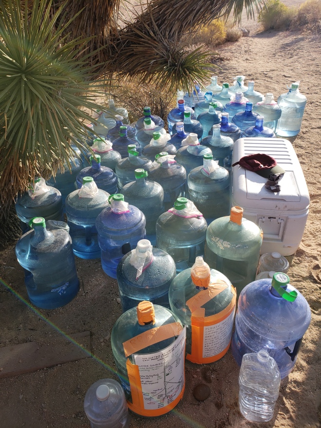
No. 4: The Water in the Desert is a Challenge, More for SOBO Hikers
When the NOBO crowd sets out in the Spring across the southern California desert, water isn’t much of an issue due to snow melt in the higher elevations and springs being abundant that time of the year. Unfortunately, southbound hikers face a serious dry spell across the 700 miles from Kennedy Meadows to the southern terminus.
NOBO
Water won’t be much of an issue for northbound hikers, with a few minor exceptions that are usually over dramatized through word of mouth (i.e. Hat Creek Rim in NorCal). In the Spring, most of the piped springs are flowing, caches are bountiful thanks to trail angels, creeks are flowing down from lofty peaks, and cisterns have water from the previous winter. The water report and Guthooks App are constantly updated, thanks to the large amount of hikers who feel compelled to contribute this important information.


SOBO
As I had mentioned previously, I started facing water issues just north of Kennedy Meadows, where once reliable creeks were dried up and forcing my hiking partner and I to do long carries, and really strategize our daily schedules.
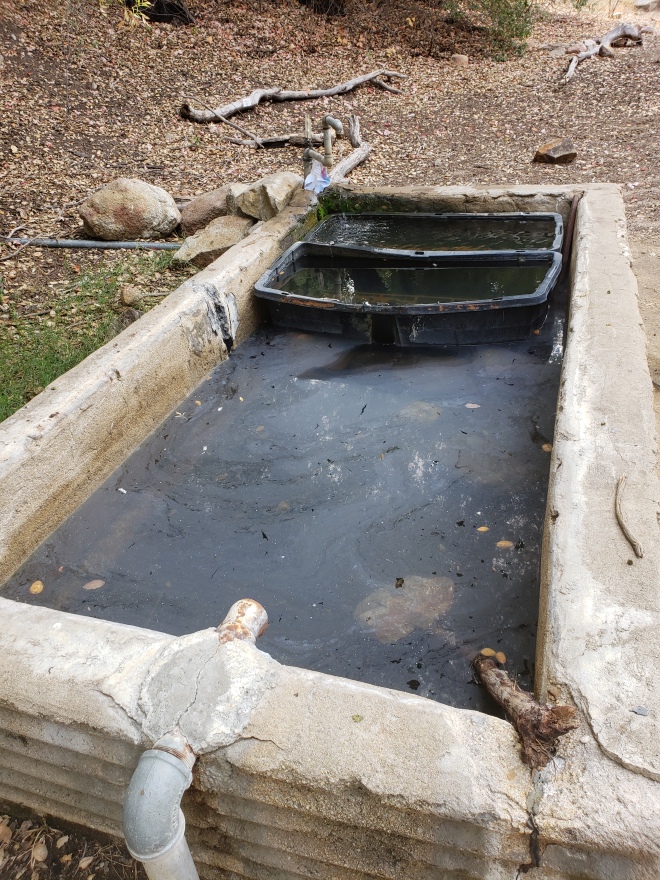
From Kennedy Meadows to Walker Pass, there very little water on this 50 plus mile stretch, where we were forced to gather water from a slimy cow trough. Not too big of a deal since we filter, but carrying four liters of water is incredibly heavy. From there, it was uncertain if there would be water at the cistern at Walker Pass Campground. No one had updated the water report in weeks, and there was contradicting information on Guthooks saying that it was dry and full, with both of those reports being made on the same day, three days prior.
Now, a water update on a spring made in July is worthless for someone going through in October. A whole hell of a lot can happen in that huge span of time, and it was frustrating that there was so much uncertainty surrounding a source. For some reason, SOBO hikers weren’t updating the official PCT Water Report, but instead leaving comments on Guthooks. This is fine, but not everyone has that app.
Another memorable dry stretch was the long, strenuous climb into Mount San Jacinto State Park, after leaving White Water Preserve. Over the course of about 20 miles, and 8000 feet of elevation gain, there’s not a drop of water. It was long, miserable and I was happy when it was finally over.

Final Thoughts
NOBO hikers are lucky in that they don’t have to worry too much about water the entire time, even in the desert. There’s even an odd amount of caches in places where you don’t necessarily need it, left by people with the best intentions. SOBO doesn’t fair as well, though, as trail angels scale back significantly on leaving caches, and much of the sources are bone dry after summer inferno has swept through.
No. 5: Washington is Gorgeous, if You Can See It
The State of Washington is 500+ miles of remote, rugged terrain that features the most elevation gains in all of the entire PCT. The scenery is beautiful, but the notorious PNW rain could ruin your good time. Timing is everything here.
NOBO
I was so excited to get to Washington on my NOBO thru-hike, because it was literally the home stretch for me: I was born and raised in a rural area outside of Seattle, and I was fully aware of how magnificent the views could be here. Imagine my disappointment when it rained almost the entire time, obstructing everything I knew and loved. I went through during the month of September, so I already knew that I’d be risking hitting bad weather as the Fall season is usually right on time in my home state. I was still holding out hope though, and trying to stay positive.
I did get lucky in the Glacier Peak Wilderness, arguably one of the best sections on the trip, with a couple of days of sunshine. However, as I neared Harts Pass the weather changed for the worst, and on the last day, I hauled the last 36 miles in one go as the first snow of the season dumped down on me. I arrived in Manning Park at just after 10 pm, cold and wet, and having hiked through blizzard like conditions over strenuous terrain.

SOBO
I began my southbound thru-hike from Harts Pass on July 5th, and it was a bluebird day. In fact, it would remain sunny and warm almost the entire length of the state, minus a rare cold front that moved in on the night before I got to Snoqualmie Pass. I finally got to see everything I had missed out on the first time, and it nearly moved me to tears.
Final Thoughts
With Washington being as scenic as it is, it seems shameful to hike it at any other time of the year other than summer. From an insider’s perspective, my home state does occasionally have an extended summer well into September, but it’s rare and I wouldn’t count on it. Plus, it’s best to not find yourself caught in the first snow storms in the North Cascades. People die up there; that corner of the country is no joke.
No. 6: No Matter Which Direction, Northern California is an Inferno
It’s hot here, uncomfortable so.
NOBO
I left the High Sierra for the NorCal sections just after the 4th of July, entering an inferno of stifling heat, through unremarkable pine forests and a trail that was favored by rattlesnakes. About half of northbound thru-hikers drop out in northern California. The excitement of the desert and High Sierra is gone, and instead replaced with the monotony of pine forests that give way to burn areas. And when you reach the halfway point, you’re still in the same state that you started in.
It goes without saying, NorCal has its moments. I thoroughly enjoyed Lassen Volcanic National Park, the Marble Mountain Wilderness, and don’t even get me started about how amazing that swim hole on the Feather River is!
But damn, it’s miserably hot here, even in the shade, and I saw more rattlesnakes here than in the desert. At one point, near the town of Burney, it was 104 F during the day. I was forced to hike the shade-less 30 mile Hat Creek Rim at night, to avoid the sun and conserve on water. When I got to town, the forecast stated the heat wave was to continue for two more days. I promptly checked into a motel room with A/C, and waited it out.

SOBO
There wasn’t much difference going through here as a SOBO; I arrived at the California state line in mid August, and it was just as hot as before, only with a little extra wildfire smoke sprinkled in for good measure. Along with my friend, we hiked Hat Creek Rim at night again, camping at the hidden water tank known as ‘Cache 22.’
We didn’t really ride out our time in any motel rooms to escape the heat, but we treated ourselves to a room in Sierra City, so we could wash off the layers of accumulated sweat and dirt that we had been collecting for several hundred miles.
Final Thoughts
The heat is unavoidable here. Try and make the best of it by hiking early in the morning and in the evenings, and having a siesta midday in the shade. Go for a dip in a river. And there’s no harm in getting a room with temperature control if need be.
No. 7: Border Entry is Not Treated the Same
Canada welcomes (most) hikers with open arms. Unfortunately, the same can’t be said about the United States.
NOBO
Before most hikers set off from Mexico, they apply for a permit to legally cross the northern border into Canada. The approval process usually takes place within a few weeks, and hikers are notified through email whether or not they can enter. Print it out, and have it on you the closer you get to the Northern Terminus. If you have a criminal record, mainly a felony or DUI/DWI conviction, then you won’t be allowed to enter the country, and you’ll have to make other arrangements (usually backtracking to Harts Pass and getting a ride from there).

SOBO
The United States does not allow hikers to enter the country via the PCT from Canada. Period. Don’t even try it. It’s illegal, and if you’re caught, you’ll be arrested and face significant jail time. Most SOBO hikers start at Harts Pass, trekking the 30 miles north to tag the border and Monument 78, and then head south again. This is an unfortunate casualty of American bureaucracy, but at least the views are epic enough that experiencing them twice isn’t such a bad thing.
Final Thoughts
The PCT Association has a page on their website detailing the process, with links to apply for a permit to enter Canada from the trail.
No. 8: The Mosquitoes in Oregon Are Legendary (And Other Oregon Myths)
The rumor mill is strong in this state for some reason. Let’s explore this phenomenon.
NOBO
The closer I got to the Oregon State line, the chatter among the thru-hikers increased, with some pretty bold claims that ‘Oregon is flat’ and ‘you can do the entire thing in less than two weeks.’ Silly me actually started to believe these rumors, and once I stepped foot into this state, I found it to be very untrue. Oregon isn’t flat at all, it just has less elevation gain than its neighbors, California and Washington. I didn’t take on the two-week challenge, as I was suffering from a pulled muscle in my neck and wasn’t physically capable of doing that kind of mileage. But I did know people who were determined to pull it off, and I started to think I was inadequate. No, I was just injured.
Another weird thing people like to say is ‘Oregon is boring.’ I’m not sure how you can say Crater Lake, Three Sisters, the Obsidian Wilderness, Jefferson Park and Mount Hood are boring, but okay.

SOBO
The same knitting circle-like talk existed this time around, too, with people saying how boring Oregon is and it’s flat, yadda yadda. But the big thing that struck me was, when we were hitting the NOBOs head on, they were going on about how awful the mosquitoes were in the southern half of the state. Some hikers even went as far as to skip around, because it was ‘that bad.’
I kept waiting to suddenly be inundated by swarms of the tiny blood suckers, but that moment never came. Was it possible that in a week’s time they all died off? Maybe, it was incredibly hot after all, and they usually f*ck off for the midday heat. But there were many stagnant ponds that simply screamed mosquito habitat, but none were in sight. For now, it will remain another Oregon myth.
Final Thoughts
As with any group of people, the rumor mill runs rampant and no one is safe from it. Take every word spoken with a grain of salt, and if it sounds too out there, it probably is.

No 9: NOBO or SOBO, the People Back Home Will Never Understand What You’re Doing
Prepare to answer a lot of questions about your hike, especially ones regarding bears.
NOBO
When I announced my intentions of thru-hiking the PCT, I was met with a lot of support, but also a lot of negativity. This is in large part because I’m female, but guys have it just as bad too.
Some of the classics include:
“You’re (spouse/girlfriend/boyfriend/partner) is letting you go do this?” I really hate this one, because it implies that your partner is in charge of your decisions. My identity in life isn’t just as a partner or ‘wifey’ (gross), I’m many things, and an adventurer is one of them.
And then there’s the favorite “what about bears?” I like to answer this one with, “what about them?” Which is usually followed up with some eye rolling and “what about cougars then?”
When I told my mother what I was doing, she instantly snapped back with “NO. YOU’RE. NOT.” Actually, I am. I’m an adult, and I’ve been working really hard for this. I’m sorry that you’re uncomfortable with the situation, but I feel good about it.
At one point on my journey, some friends and family back home offered to send me care packages, and I was thrilled to receive them! I sent them info on my next stop, and then picked up the package once I got there. As kind as this gesture is and I 100% appreciated it, if your friends or family don’t backpack, then assume you won’t get backpacking food. One time I stared down at a box full of meal replacement bars, intended for weight loss and bragging on the packaging that it only contained 90 calories. Uh-oh. I checked the label, and there it was: diarrhea inducing artificial sweeteners, that result in bloated bellies, cramps and fiery poops should you dare eat more than one in a day. Unfortunately, I had to toss them into a hiker box. I didn’t want to risk shitting myself the rest of the way to Canada.

SOBO
Since this was my second thru-hike of the PCT, my family and friends didn’t bat an eyelash when I told them my intentions. I guess this meant they had confidence in my ability to make it out safely, or they thought I was a lost cause. Either way, it worked out.
My friends on the trail suffered some of the same situations as I did the last time, with push back from partners and family to quit the trail, and surprise care packages. One of the boxes my friend got was over fifty pounds, and was so heavy that he had to take a Uber from the post office back to the motel room he was staying in because he couldn’t schlep it across town. Another friend was sent diarrhea bars, and had to have an awkward conversation with her family back home explaining why she didn’t want them sent anymore.
Final Thoughts
It’s nice to know that your loved ones care about you, and have your health and safety in on their minds. There’s no real way to assure them everything is going to be okay, especially if they’re not outdoors people. The media likes to dramatize the bad things that happen outside, and you only ever hear about bear attacks and other unpleasant things in the news without any context. Bears attacking people is extremely rare, and there hasn’t actually been a single case of it happening on the PCT. Other things that haven’t happened on the PCT: cougar attacks and murder. As far as the disapproval goes, they’ll eventually grow out of it the more you progress on the trail and prove yourself as a strong individual. But it’s good to know someone has your back in case things do go wrong.
I don’t have any advice regarding the poo bars, though.

NOBO or SOBO: Which Direction Will You Choose?
Whether you’re thru-hiking north towards Canada, going against the grain on a southbound adventure, or even doing the unconventional flip-flop, it’s important to know what you’re up against. Different weather, trail conditions and even social settings all pose challenges to the potential PCT thru-hiker.
The key here is do your research well in advance, taking into consideration the kind of gear you will need for the different parts of your hike.
Happy trails all, and best of luck to all the future PCT thru-hikers out there!
-Artemis

P.S: Want to read more about prepping for the PCT? Here’s a post about budgeting for my thru-hike, and my gear review for my SOBO journey.

Thanks once again for sharing your wisdom. Permit time rolled around so I opted for a middle course, Ashland-northern terminus, flip back to Ashland and continue South. Watching the snotel data last winter didn’t convince me of my predictive skill, and practice with the ice axe didn’t comfort me much either. Then I ran across the narrative of a hiker named Huck on the pctsouthbound site and it gave me the idea. Your comments concerning water down south are much on my mind now.
One nifty thing I ran across that has considerably bolstered my confidence in my map and compass work is an app called PeakFinder.
LikeLike
Glad to hear you applied for your permit, and decided on a flip flop: the best of both worlds! And Peakfinder is a very handy app!
LikeLike
I think my comment went away, so I will try again. Love your blog, and hoping you can tell me which direction you thought felt like less uphill in oregon and California. I am almost done section hiking washington, and would like to finish the whole trail bit by bit.I did 500 miles on the AT,and I think that’s about my max for a section.
LikeLike
I’ve enjoyed your articles; they include a perspective that I’ve not seen in others.
I hiked PCT WA this summer and agree “Washington State is simply beautiful”. I’m looking forward to hiking OR next summer.
LikeLike
I really enjoyed this article as I’ve been pondering which direction I’ll go on the PCT. In a low snow year for the cascades, I’d definitely lean SOBO, especially as escaping NOBO crowds and finding more solitude is appealing to me. Wondering which you preferred, SOBO or NOBO, if you have a definitive answer to that. Thanks again for the article and sharing your unique perspective!
LikeLike