
Trail journal lucky number 13! In this rather exciting stretch of trail through the High Sierra, scenic and otherwise, we aim for a ‘pass per day goal’, nearly run out of food, are saved by a chocolate crepe as well as the kindness of strangers, have a magical pooping experience, and witness some pretty epic countryside. The theme of this post is ‘Ration!’ Here’s the latest shenanigans from the Pacific Crest Trail.

Day 80: Deer Creek to Mono Creek, via Silver Pass,22 miles
I awake early; too early to be packing up and starting my day. I fumble around looking for my phone to see what time it is. It’s still dark, although the moon is illuminating the inside of my tent. I’m shivering, and that’s exactly why I’m awake at 2:30 in the morning. There’s no frost on my tent this time around, but I toss and turn until it’s actually time to get up. I crawl out of my bag to go pee, grab my bear canister, and make a strong cup of cold instant coffee with Ovaltine mixed in; it’s the best I can do for my breakfast considering the selection at Reds Meadow’s store the prior day.
I’m tired today, and Cheesy Puff and I have a lot of climbing to do. We’re both lacking in sleep from the extreme cold, and it’s caught up to us. After only five miles in, we stop at a creek and make a second round of coffee. The sun warms my back and shoulders as I sit, and I want to trap its warmth under my skin and carry it to camp with me, then fill the inside of my bag with it. I need to get some solid sleep, and I need to be warm to do so.
The day heats up as we continue climbing the dusty switchbacks towards a series of turquoise lakes: Ram Lake, Purple Lake, and Lake Virginia. The breeze creates dappled effect on the surface of their waters and leaves a silvery sparkle floating on top. We don’t stop, knowing that we have a pass to get over before the end of the day.
One pass per day, possibly two; this will be the rule that we live by to get us through the Sierra Range before we’re hit with its first winter storm of the season.

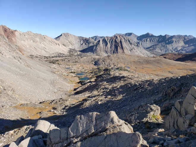
We descend into a river valley, where Fish Creek is winding its way through a meadow and then rushing through a deep gorge. There’s a lovely clearing near the creek, flooded in sunshine, and we rest there for our lunch. From here, we begin our ascent to Silver Pass, which is at around 10,700 feet elevation.
I feel more energized after lunch, and the climb to the pass isn’t all that bad. We scramble over rock fields, and cross the outlet for Squaw Lake, and then continue on up to Chief Lake. Both are stunningly beautiful examples of the lakes found here in the high Sierra, sparkling and a vivid blue. A marmot momentarily distracts us with its charm, as do the sparkling alpine lakes and lofty peaks that can be seen in every direction. At the high point just above the pass, a group of JMT thru-hikers are making their way up.
“You make it look easy,” they say, and we fly past them on the downhill. My feet are aching now and we’re ready to get to camp and eat dinner. I smile timidly and thank them, but I think that the sleep deprivation must be showing across my face. My eyes feel like caverns. The descent is long and slow, traversing ankle-rolling rocks on loose grit. We have a short break beside a shallow flowing creek, eat our dinners, and move on toward camp.


I pull ahead of Cheesy Puff in the last few miles before camp, and pass a couple of women who are hiking the JMT. They admire my tan, and ask how long I’ve been out here. I tell them I’m a PCT hiker, southbound, and I’ve been out for just under three months. They say that I’m an inspiration, but I don’t feel that way. I point to Cheese, coming up from behind, saying she’s been with me from the start. They’re impressed, but I’m run-down. I can feel the stiffening of my legs as I pause to talk. I love this section of the trail, in fact, it’s my third time through. But all I want right now is to fall into bed and sleep forever.
We arrive at a steel bridge over Mono Creek, near the trail junction for Vermilion Valley, early in the evening. There’s several flat campsites nearby to choose from, and we take a couple of the hidden ones in the trees. The chipmunks and ground squirrels are busy, scurrying around with bits of hard-earned food in their cheeks. They’re preparing for winter, which is nipping at our heels since Sonora Pass.

I’ve heard that eating fatty foods before bed makes you sleep warmer, and I’m desperate. I consume every fatty food worth carrying: peanut butter, summer sausage, cheese and chocolate; an entire smorgasbord of rich delights tucked inside of tortillas. I enjoy eating these foods, but my gut is in turmoil. I also try my best at some hygiene before sleep, and brush my hair that hasn’t seen a comb since South Lake Tahoe. It doesn’t go well, and I pull clumps of knotted hair from my head.
I’m feeling defeated, and fall asleep rather easily.
Day 81: Mono Creek to South Fork San Joaquin Bridge, via Selden Pass, 25 miles
A phenomenon has occurred overnight: I stayed warm, through the entire night and actually felt rested when I woke up. Not only that, but at one point I was too warm and had to peel off one of my layers. Hallelujah, my prayers have been answered!
Cheesy Puff also woke up feeling good, and we both had extra pep in our steps as we set off in the morning. Almost immediately, we’re faced with an enormous climb out of the canyon that we had camped in, and we charge the three miles up the forested switchbacks. There’s nothing better to get the blood pumping back into your legs than a 2000 foot gain in the first hour.
The trail plateaus at the top of the hill, meandering across pine forest and then eventually giving way to aspen and juniper on the descent. We lose elevation just as fast as we gained it, traveling under a canopy of fluttering golden aspens and crossing clear flowing springs. At the bottom, we follow Bear Creek for some time before eventually fording it.

From Bear Creek, we begin our ascent towards Selden Pass, winding our way up through giant granite boulders. A wind comes up from the north, pressing against our backs with a frigid force that reminds us that winter is very near.
We pass glittering lakes on the way to the top of the pass, and a peak that has the ancient grooves of a million years worth of glaciers leaving their mark. The climb to the pass isn’t at all too strenuous, and Cheesy Puff and I gesture a couple of small shrugs at each other once we’re at the top. On the other side of the pass, we find a warm spot beside a creek and in the sun, where we enjoy our lunches. My joy of eating, however, is suddenly cut short when I realize how little food I have on hand. I must have miscalculated our days or been lacking in self-control. We have three solid days left on trail before we get to the town of Independence, and I only have maybe two days worth of food.


We decide to see if Muir Trail Ranch is still operating, since we heard through the hiker grapevine that there were buckets of free food left by the JMTers. Unfortunately, when we ask some other hikers passing in the opposite direction, that inform us that yesterday was their last day open for the season.
Shit.
I ration my food for the remainder of the day, which mainly has us going downhill and not working up too much of an appetite. Regardless, the last few miles are rocky and painful on my feet, and my hunger is making me grumpy. How could I let this happen?
We cross the bridge at Paiute Creek and enter Kings Canyon National Park. Cheesy Puff is grumpy now too, but her frustration is directed at the characters in an audiobook she’s reading, and after beating her filthy sock against a log, she goes down to the edge of the creek to sulk and get water. We follow the South Fork San Joaquin River for a couple of miles along a canyon wall, and then find an empty campsite along the shore.


I take a full inventory of my food after making camp, separating my goods into a few days rations and eating a bit of peanut butter and chocolate for my dinner. Cheesy Puff donates a package of ramen to me, which I’m eternally grateful for. I had seen a group of campers across the river on our way in, and I briefly consider begging for any surplus food they might have. But it’s dark now, and I climb inside of tent and let the shame consume me.
Day 82: South Fork San Joaquin River Camp to Palisade Creek Camp, via Muir Pass, 27 miles
Nature calls first thing in the morning, before day break, and I’m scrambling out of my tent and trying to find a respectable place in the woods to do my business. Afterwards, I grab my bear canister and retreat back to the warmth of my bag and dig through my meager food stash for my instant coffee. I slept warm again, and through the night, and I’m feeling pretty good about the day ahead despite my embarrassingly low food inventory.
Cheesy Puff and I start our day following the San Joaquin, through more aspen forest, where the cold air of the night is trapped and smells like a damp river bank, loamy and like the combination of alive and dead leaves. We pass more tents in spacious campsites, palaces compared to our shelters; their inhabitants emerging groggy and bundled against the cold. Soon we cross the river on a wooden bridge, and start climbing away from the canyon.

The trail ascends over rocky canyon walls, with Evolution Creek spilling down rapidly beside us. Ancient junipers twist over us, hanging onto the cliff side for dear life. We climb for what feels like ages, and my stomach hurts with emptiness. I eat a protein bar as I walk, savoring every gritty bite and hoping it will stave off hunger until I reach the top of Muir Pass.
We reach Evolution meadow, and ford a shallow point in the creek. Up until this point, all the creeks we’ve encountered in the Sierra have been easily crossed on stones or logs. Now, we hike on with soggy feet. At Evolution Lake, we pass a large group of JMT hikers, and one of them calls out to us, giving us encouragement and two thumbs up. I smile and wave, and wonder if they have any spare food.


As we’re skirting the edge of the lake, and contemplating where to have a short break before our final push to the pass, Cheesy Puff makes a discovery that can only be described as something just short of a miracle: a chocolate filled French crepe, still in its original wrapper, resting on the ground beside the trail. We squeal in delight, and find a rock to perch ourselves on while we split it. She tears it in half, and we chow down on its chocolatey goodness. How did we get so lucky in this time of need? I make another round of coffee and Ovaltine, something I actually have an abundance of, and ponder why Ovaltine has been a thing for so long. It’s pretty gross, chalky and a bit flavorless, but it’s fairly calorie dense so it’ll do for now.


The final climb to Muir Pass is marked by rocky trail and switchbacks, and the elevation has us gasping for air. But we power up it anyway, our spirits high from finding the crepe. We pass the big group of hikers again, who had previously passed us during our break, and they cheer us on as we go. At the top, we high-five each other and declare victory, and then collapse onto a couple of rocks to rest. Our hunger has returned.
The big group arrives, impressed by our speed up to the pass. The woman in the group chats with us excitedly, wondering if we ran track in college. I hadn’t, but Cheese did. We casually bring up the fact that we’re low on food, and they enthusiastically dig through their bags, pulling out spare food. I feel like an asshole, and they’re treating me like a god damn celebrity. I’ve put myself in this situation after all, and I have only myself to blame.
The woman is very kind, insisting on giving me food. “We ran into a ranger at the last patrol station, and he gave us his extra food since he was closing up for the season.”
In all, they give us each a couple of candy bars, two fruit and nut bars, half of a loaf of bread, and some Annie’s Mac and Cheese. It’s so great, I could cry. I eat the candy bar and add the rest to my food inventory, and we check out the interior of the Muir Hut before heading out again.


The descent is incredibly long, following a knee grinding path that follows the Middle Fork Kings River down into La Conte Canyon. Shadowy mountains loom over us as we go, and evening creeps into the canyon, bringing a chill with it. The light of day is fading quickly, and we need to hurry.
After stopping to get water near Big Pete Meadow, we rush through the canyon to get to camp. It’s getting colder with every step, and I don’t want to be caught hiking in the dark. Several deer have ventured out near the trail, and go scattering as we hurry past them. We finally reach our camp, a spot along the Palisades Creek and within a patch of aspen trees, as night falls and we’re forced to set up by the light of our headlamps. We eat our small dinner huddled together over a fire pit, in which we have no fire, and then retire to our respective shelters. The sound of the creek is gentle here, sprawling out in a few forks across the neighboring meadow, and I’m happy to have it lull me to sleep.


Day 83: Palisade Creek Camp to Canyon Camp, via Mather & Pinchot Passes, 25 miles
I wake up with first light, and scurry out of my tent into the brisk morning to go use the bathroom. As it turns out, pooping in an aspen meadow is a pretty darn magical experience. A squirrel keeps me entertained while I’m going, by meticulously dissecting a large pine cone right down to its nut.

When I return, Cheesy Puff is up, so we break camp and start hiking again. This time our sights are set conquering two passes today, Mather and Pinchot, with both being above 12,000 feet in elevation. It’s an ambitious feat, yes, but I’m confident that we can accomplish it. The morning has us walking in the shadow of La Conte canyon’s deep walls, with sun slowly coming up from behind us. At the end of the canyon, Palisades Creek tumbles down in a thin, misty stream, and we begin our ascent towards Mather Pass. In the basin for Lower Palisades Lake, we stop to catch our breath and I make a quick mix of matcha tea to see me through. My stomach is growling fiercely at me, but I need to stick to my guns and avoid devouring all of my food.


Above the lake, it’s otherworldly: tree-less terrain, rocky and as cold as an ice-box despite the sunshine. I hike with my head down, focusing on my breathing and the steps that I take, and pausing for only a few seconds on the pin turns of switchbacks to regain my composition. At the narrow saddle that is the pass, I reward myself with a break, sitting on a flat boulder and taking a few nibbles of crystallized orange peel. One pass down, one to go.
On the other side of Mather Pass, one can see for miles on end. We can also see the course of the trail, winding down the steep angle of the mountain through a series of switchbacks, and then straight across a flat plain off into the oblivion, where it seemingly drops off into nothing.


It’s a long way down the other side of the pass, crisscrossing the slope on loose grit, watching stones tumble down after I inadvertently dislodge them. We cross the plain, looking for flowing water where we can refill and rest for a bit, but nearly all the creek beds are either dry or stagnant. We eventually find one, clear and cool, and with a flat rock big enough for us to lay across and catch the warmth of the sun. I eat my paltry lunch and a double batch of coffee.


The trek across the plain ends rather abruptly, dropping us into the forested river valley for the South Fork of the Kings River. This river ford brings back memories of anxiety and fear: it was here that I forded the hardest river of my life, facing the current with another thru-hiker in 2016, taking small steps across slimy rocks in waist deep water, and nearly losing my footing. Seeing my life flash before my eyes, which I didn’t know was a thing until then. Just prior to that ford, another hiker had been swept away and then miraculously plucked from its rapids by a member of his trail family. And last year, a thru-hiker sadly drowned in this spot. But I stand before it now, staring from one bank across to the other, with a shallow veil of water barely covering the rocks between me and the far shore. The river looks pathetic now, but it’s an important reminder of what she’s capable of.
We ford the trickle of a river, startling another hiker on the opposite bank that hadn’t noticed us before. From here, we begin our second big climb of the day, heading towards Pinchot Pass. Leaving the river valley, we transcend the treeline and enter a landscape of white stone and alpine lake basins, with the occasional gnarled bristlecone pine adding to the mystic vibe of our surroundings.


The climb to Pinchot Pass is routine feeling, adrenaline charged and surprisingly quick. At the top, I eat more orange peels, and dip into my rations to eat a candy bar. There’s two more thru-hikers at the top, Iron Horse and Nails, flip-floppers returning to finish up the California stretches they had bypassed earlier in the season. Cheesy Puff and I waste little time with a break, night is on the horizon and we’re looking forward to camp after a very physically demanding day. It’s another tedious descent in front of us, and we get to it, powered by a third or fourth wind.
The trail flanks the river, down into a canyon. We settle on a campsite within the trees, and I go fetch water from the river for the both of us. We have our dinner in the dark, perched on a log near a fire pit. I eat the rest of my freeze-dried chicken and rice, which I’d split into two portions, and when Cheese offers me the rest of her couscous, I eat that too. I go to bed full and happy, with only the sound of the river in the distance to be heard.
Day 84: Canyon Camp to Independence, via Glen & Kearsarge Passes, 21 miles
Somewhat surprisingly, I’ve been staying warm throughout the nights, but I’m still looking forward to collecting my sleeping bag liner in Independence. At daybreak, we head down to the bank of the river to collect water, which numbs my fingers. We continue down the trail and through the canyon, slowing losing elevation until we reach the suspension bridge over the Kings River. On the far end of the river bank, it’s a JMT hiker mob, with so many congregated in the large campsite that they’re nearly piled on top of one another. Everyone is staring as we pass, wearing thick layers, faces puffy with sleep and spooning breakfast mush into their mouths. It’s an odd sight to say the least. Are they all following some predetermined itinerary? I have so many questions…

We leave the canyon behind, following a gentle grade into an area with more lake basins. We’re prepared for another twofer today: Glen Pass, and then the side trail over Kearsarge Pass and into the Onion Valley, where we’ll be going into Independence from there for resupply. After what we’ve accomplished so far with mileage, I’m feeling good about the day; confident and strong.
The area around Rae Lakes is breathtaking, with rocky peaks mirrored in the pristine waters of the lakes. There’s many hikers on the trail today, and they have one comment or another about our speed as we pass them. Some are a bit haughty, but most are nice. We stop at one of the lakes to fill up our water and have a quick bite, and to take in the view of course. It’s a bluebird day, warm and pleasant.


From Rae Lakes, we begin our ascent to Glen Pass. I have a decent amount of stamina left in me, and I march up the switchbacks to the pass. I dream about what delicious treats there are in the town ahead, realizing that I am 100% driven by food on this trail, not that this a revelation by any means. I remember that there is a Subway Sandwich shop in Independence, and now I’m dreaming, out loud with Cheesy Puff, which sandwiches I’m going to get. It will certainly be no less than four, and stuffed with every vegetable that they have.
We pass more groups of people on the way up, and the narrow knife-edge saddle at the summit is packed with hikers. We find an open space of rocks to sit on, taking a moment to rest our burning leg muscles. A woman tells us we look ‘well seasoned’ and offers to take our picture. We eat a snack, and then we’re off again down the opposite side.


There’s surprisingly no water on our descent. In fact, it’s as dry as a desert out here and we’re down to our last few sips. Naturally, there’s an inaccessible lake tucked away in a bowl that taunts us. Cheese confirms a water source halfway up Kearsarge, some four miles ahead, nut the report is two weeks old and untrustworthy. We meet another SOBO thru-hiker, a man called Dorothy from Kansas, near the junction for Kearsarge Pass, and he’s worried about water too.

Cheesy Puff and I hang back at the junction for a rest in the shade while Dorothy goes onward, and we sit beneath a tree to drink the last of our water, and I finish off the last couple of scoops of my peanut butter. There’s a group of JMT hikers there, men who appear to be around retirement age, sifting through their food bags. One of them offers us some packets of tuna, which we happily accept and inhale. Another one, however, is a condescending jerk.
“Are you going over Kearsarge today?” he asks.
“Yes.”
“Okay, well when I saw you I thought, if they can do it, then I definitely can do it.”
Our jaws drop, and his mates look stricken with embarrassment and a bit of fear. Cheesy Puff laughs in a way that says, are you for real?
“We’re PCT hikers,” I firmly tell him. “We’ve already come 1800 plus miles, and we did two passes yesterday, and we’re going to do two today.” He looks away, but my stare is fixed on him. I’m pissed. I want to yell and scream at him for being a pig, as he looks like someone who favors an arm charm more than any activity, and to assume that we are weaker than him is utterly ridiculous and insulting. We bite our tongues further though, and show him up by charging up the trail. It’s the last we see of them, and by the time they were probably done hemming-and-hawing over whether or not to go over the pass, we had reached the top.


We hurry down Kearsarge Pass; we can smell the fresh-baked bread from here! The trail abounds with day hikers, which could possibly mean a hitch out from the Onion Valley if we play our cards right. We schmooze with them as we pass, asking how their day is, complimenting gear and telling them to have a great hike.
The switchbacks down feel like an eternity, winding thorough boulders and sparse trees, and past lakes and noble peaks. By the time we reach the Onion Valley, it’s past the closing time for the post office in Independence, meaning we’ll have to stay in town for the night. We’re okay with this, as we’re long overdue for a shower. Dorothy is there too looking for a ride into town, but the there’s not a soul in sight, despite the parking lot being pretty full. I rub hand sanitizer on my hands, arms and neck, hoping to disguise my current ripeness, and we stick out our thumbs to a woman who’s just leaving the campground. Shockingly, she stops and tells us to pile in.
The ride down into town is quiet, and a bit awkward. Our ride isn’t too talkative, which is fine. The three of us are crammed in the back seat, holding our packs on our laps and trying not to invade each others’ space. She drops us off in front of the post office, and it’s like jumping out into a furnace. The tolerable temperatures of the high Sierra have disappeared with our elevation loss into the Owen Valley, and it’s easily 100 degrees outside. And in another shocking blow, we discover that the Subway Sandwich shop is no longer operating, and the so-called pizza place that had taken its place, is also boarded up.

Cheesy Puff and I settle on microwave burritos for our dinner, and a mass of junk food like popcorn, soda and red licorice. We get a room at the Courthouse Inn, situated across the street from the Independence Courthouse where Charles Manson and a handful of his followers were held after their capture. Our room has everything we could ask for: a microwave, mini fridge, and most importantly, a shower and air conditioner. Dorothy is in the room next to us, and offers to let us throw our clothes in with his load of laundry. So we strip down into our rain coats and wrap a towel around our butts, and graciously accept such a generous offer. We spend the night like this, in our amazing ‘laundry day’ outfits, post shower, downing junk food and watching the worst Lifetime movie on TV.
It’s perfect.


I love love love these journal posts so much, living vicariously through you 100%
LikeLike