In this 86 mile section of the Arizona Trail, I climb Mica Mountain in the Rincon Range through Saguaro National Park, weather a storm on Oracle Ridge, attempt to survive a sub freezing night, and meet a sassy trail angel. 200 miles down, and only 600 to go! It’s been awhile since I posted last, so here’s the second dispatch from my AZT thru-hike.
Update: 12/29
Hey folks, and welcome. As you may have guessed, I’m finished with the Arizona Trail, having successfully finished an exhausting thru-hike in 5 weeks. As per usual, I’m catching up my journals from the trail; pouring over notes I took, photos I snapped, and fondly remembering the type two fun that was had over those 800 miles of incredibly challenging terrain.
Also, somewhere in between my finish date on the AZT in early April and the present, I thru-hiked the 3000 mile Continental Divide Trail from Canada to Mexico. I had other plans to hike a different trail (the PNT), but suddenly came down with a yearning to tackle a trail that both excited and scared me. I’ll post more on the CDT at a later time.
So without further ado, here’s part 2 of my AZT journal, from Vail to Oracle. And thanks for hanging in there with me!
Day 6: Vail to Saguaro NP Southern Boundary, 14 miles

Trail angel Eli picks me up in the morning from my motel on the outskirts of Tucson, and drives me back into Vail. He’s hitting up a section hike in a few days down south, near Patagonia, and is eager to know details about the detour and water situation. He drops me back off at the Gabe Zimmerman trailhead, and I set off once again. The swelling in my knee has decreased dramatically, thanks to ice and Benadryl, and I’m looking forward to getting back to trail life.
The day is bright and warm, but a cool breeze is keeping me from baking under the Arizona sun. The trail meanders away from the trailhead, first under a railway bridge and then over dusty rolling hills abundant with Saguaros. By midday, I reach a covered picnic area at Colossal Cave and the shade is too welcoming to pass up. I grab some water from the spigot, and hole up under the stone structure at a picnic table. A cyclist joins me for a bit, and we shoot the breeze over lunch. A roadrunner darts across the open spaces.


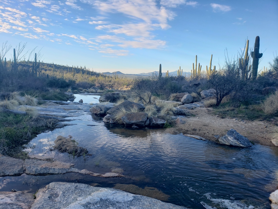
Several day hikers pass me in the opposite direction further north, shielding themselves from the sun under large floppy hats and full coverage hiking clothes that make swishing sounds when they walk past. The crowds lessen when I get closer to Rincon Creek, which is a decent ford; moving along at a good rate and cloudy with sediment. Once on the other side, I fill up on water for the night and make my way to the boundary for Saguaro National Park.
I hole up in the shade under a big NPS informational sign, and assemble a few cold soaked black bean burritos for dinner. It’s early yet, but I don’t have a permit to camp within the park legally, so here is where I will make my bed for the night. I ditch my gear for a bit after dinner, walking into the park to admire a rather large Saguaro, and to scope a tank at a stock camp a quarter of a mile in. The tank is bone dry, so I head back to pitch my shelter just as the golden hour sweeps across the desert.


After popping a Benadryl and fully committing to an early bedtime, another hiker called Soul Queen rolls in just as I’m staking out my tarp. We sit across the trail from one another in the fading light, chatting about the recent conditions while I eat a second dinner of peanut butter wraps and chocolate.
Sleep comes fairly easily, despite the short mileage day. Another warm night, and I’m feeling mighty good.
Day 7: Saguaro NP Southern Boundary to Italian Trap Trailhead, 22 miles

The morning is cool and dewy, with golden rays of sunshine stitching together with blue skies. Within the first few miles, I reach a clear flowing creek, and I stop to make a round of coffee and eat a quick breakfast. The air smells like sage, and I breath it deep into my lungs.
Once daylight fills the valley in the park, the sunshine comes on in blinding, white heat. I’m practically gasping for air with every step I take, stripping layers of clothing off and slathering sunscreen on my face. I start gaining elevation rapidly, making my way up Mica Mountain. The Saguaros peter off around the 4000 foot mark, and give way to twisted manzanita shrubs and waifish lodge pole pines. My sinuses are displeased with the dry conditions and my nose drips blood.


I stop alongside a rushing creek for a snack, and the air has cooled off significantly at these higher elevations, to the point that I have to layer up again and warm myself under the midday sun. This trail is bipolar.
There’s a grand view of the Sonoran Desert below me, and the Sky Islands that I’ve already traversed. I pass through the Grass Shack campground, filled with tents and slightly flooded out from all the recent snow melt, and continue my tedious climb.
The stifling desert temperatures are long gone, and I bundle up for my lunch break while sitting in between two gushing waterfalls. It’s dense ponderosa forest now, a stark contrast to what I’ve just come up from, and patches of snow are starting to make an appearance.
After lunch, the patches of snow become a full on trudge through a soggy forest, and I’m post holing and route finding my way towards Manning Camp. There’s a volunteer youth group gathered at the patrol cabin, being directed as to what trail maintenence they’ll be up against, and they look less than thrilled to be there. Further on, I follow another creek, and come across two young women sitting on a small snow free patch of earth under a tree.


“This is the hardest thing I’ve ever done in my life.” A pained statement, and they both look exhausted. I push on, eager to summit and descend below snow line before it gets dark. I have my eyes on making camp at a road crossing, but it’s still several miles out and these conditions have slowed my pace considerably.
At the summit of Mica, the air is sharp and frigid, and I temporarily lose the trail under the snow. I follow foot prints down the mountainside, tracking my route closely on Guthook. My feet are wet and cold, and to make matters worse, the lower flick lock on one of my trekking poles has popped off completely, rendering this important piece of gear worthless. I can’t be bothered to look for it in the slush and underbrush; all I want is to get off this mountain, out of the snow, and under my quilt.
A trail register marks the northern boundary of the park, and from here on out it’s snow free and back into beige desert. The sun in low on the horizon now, and I’ve abandoned by former campsite goals for a trailhead that’s just a few miles ahead. I ford a silty creek, filling up my Talenti jar in the process to cold soak a packet of ramen, and push my aching body towards the salvation of camp.


By the time I arrive at Italian Trap Trailhead, it’s dusk. My knee is giving me hell from the long descent I’ve just endured, and this campsite couldn’t have appeared at a more appropriate time. There are two more hikers there settling in, and I introduce myself so as not to startle them. There’s a level area beneath a mesquite tree, and I clear away any prickles and cow pies. I throw up my shelter, and stuff my face with ramen and sweets as I lay in my bivy. The crickets string together a tune, and the comforting sounds help lull me into slumber.
Day 8: Italian Trap Trailhead to Cathedral Rock Junction, 25 miles

When I wake up, the coyotes were just getting started with their routine howls. What do they say to each other? I rub my knee tenderly and then bend it; still stiff as a board and sore as hell. I grease it up with CBD cream and wrap the small piece of ace bandage I have around it, creating a slight compression. At the first sign of daylight, I’m off.
The trail cuts through tall grass, rambling over hills and in and out of arroyos. It’s an oddly humid day, with the slightest breeze breaking through the stickiness from time to time. I stop for breakfast at a slimy stock pond, doing the fill up and filter ritual, and I eat a bag of candy and some Clif Bars for my breakfast. Further up, I cross paths with Lexi, another thru-hiker who’s doing the flip flop thing after dealing with too much snow at the beginning. She fills me in on the impending bad weather that’s hitting the higher elevations in the next couple of days, and recommends sleeping in the public bathrooms in Summerhaven if need be.
The trail begins to climb, back into sage covered hills and red rock canyon. I pass a couple of wild horses, giving them a wide berth as they eye me suspiciously. At the top of the climb, I catch views of a picnic area near a front country campground; as well as a couple of pit toilets that I’m fully prepared to take advantage of. I hurry down to towards these modest creature comforts, and stake a claim at a covered picnic table. My knee is ready to be elevated for a bit, and my bag of potato chips isn’t going to eat itself.


The trail skirts the campground, winding back up into the hills and towards Sabino Canyon. I pass another thru-hiker who goes by Lotus and we chat for a minute or two, and then begin my long downward push into the canyon. The air is still muggy, and there’s a feeling of electricity lingering in the atmosphere. I need to make it camp soon, somewhere below tree line in case of thunder and lightning.
I cross the first of several fast flowing creeks, with Sabino Creek being wider and swollen, waist deep and sediment filled. I start to climb again, dipping in and out of smaller gulches, passing by more Saguaros and into riparian forest.


The forest is dark when I arrive to my camp at a trail junction. Bats dart above my head, and I hurry to pitch my shelter. The air is thick and loamy here, and I feel like I’m camping in a jungle rather than a desert. Dinner is wolfed down while sitting propped up against a log, and in the pitch black of the night. The light of my headlamp is focused solely on my peanut butter wrap, for fear I might catch a pair of glowing eyes looking back at me from the forest. This is mountain lion territory, after all, and I’d rather not see the creature that wishes to devour me.
The creek provides decent white noise as I lay down and try to ease my mind a bit, but hip and knee pain has me tossing around inside my bivy, looking for that sweet spot. I’m exhausted in every way, and soon it overcomes me despite the pain.
Day 9: Cathedral Rock Junction to Dirt Road, 18 miles

When I wake up, a storm is looming. The humidity of the previous day has given way to an icy wind that’s whipping my tarp at the corners. I pack up quickly, and charge up towards Romero Pass to try and get the blood flowing. Snow flutters down at the pass, and visibility is poor.
Lexi had warned me about the trail conditions in the elevations above Romero Pass, and much to my dismay, she was spot on. The trail is lost under snow, and my shoes are once again soggy.


The trail winds its way through hoodoo rock formations and then pine forest the closer I get to Mount Lemmon. The weather is bitterly cold, and the wind continues to pick up. I cross several flooded out creeks, and fight through thick overgrowth. My first glimpse of civilization comes when the trail widens, and the sounds of giggling are heard just ahead: a group of teenagers, in light clothing and squeaky clean sneakers, are having a good time taking selfies. I’m close, town is very nearby.
The gate accessing the trailhead from the road is still closed, as are the pit toilets, much to my dismay. Groups of tourists are walking in from up the road, and I hurry into the direction of town. First stop is the post office, where I stuff a ridiculous amount of food into my pack after collecting my resupply box. Next up, a much needed hot meal at the bar and grill next door.
I ask for a table near an outlet so I can charge up my electronics, and order hot coffee and soup. The wind is tunneling through the center of town and is as loud as a freight train. I’m absolutely dreading going back out, and seriously considering sleeping in the public bathroom at the visitors center. But it’s early yet, and more time in town means more money spent.
I loiter around the restaurant, drinking cup after cup of coffee and utilizing the wifi. When the weather has calmed a bit, I push onward down the highway and back onto the trail.

The trail follows a narrow path along Oracle Ridge, which is socked in and getting pounded with pwerful gusts and snow. I huddle under a cluster of trees to get some relief from the weather, but head out to brave the elements in hopes of getting off the ridge before dark.
Below the ridge, the sun makes an appearance, although the wind continues. I need reprieve! I’m freezing cold, and need to camp in a sheltered area from this wind. I find a semi protected area on a dirt road, on uneven ground. It’ll have to do. My hiker friend Lotus, from Sabino Canyon, rolls in at dark and makes camp beside me. I know I’m in for a rough night at these sub freezing temperatures, and curl up tight into my quilt, tucking myself in as to eliminate any drafts.


Day 10: Dirt Road to American Flag Trailhead, NERO in Oracle, 7 miles
The cold wind has my nose dripping at around the current flow pace as my Sawyer filter; annoyingly slow. And to add more salt to the wound, the familiar pains of my monthly ‘special lady time’ are plaguing my body. Ugh.
I’ve barely slept a wink all night; tossing and turning from hip pain, and re-tucking my quilt under me to ward off the cold. My toes and hands are numb. I decide to pack up in the dark, and head out towards the little town of Oracle as the sun starts coming up over the horizon. I’m dead tired, emotionally and physically, and in desperate need of solid sleep.
It’s much warmer today, and I collect water from a stock tank beside the trail. Oracle is only a few miles off, and the local motel proprietor, Marnie, is famous for her hospitality. I give her a call once I get service, and she agrees to pick me up from the American Flag Trailhead. I wait around at the trailhead for a bit, watching the wind kick up and carry off clouds of dust.
A white pickup truck rips up the road around noon, and a couple of backpackers hop out. Marnie motions for me to climb in, and gives me a rundown of the booming metropolis that is Oracle.
“You’re resupply options are the Dollar General or Circle K. I have a bike you can borrow to run into town. Eat at the cafe, it’s awesome. The steakhouse sucks.”
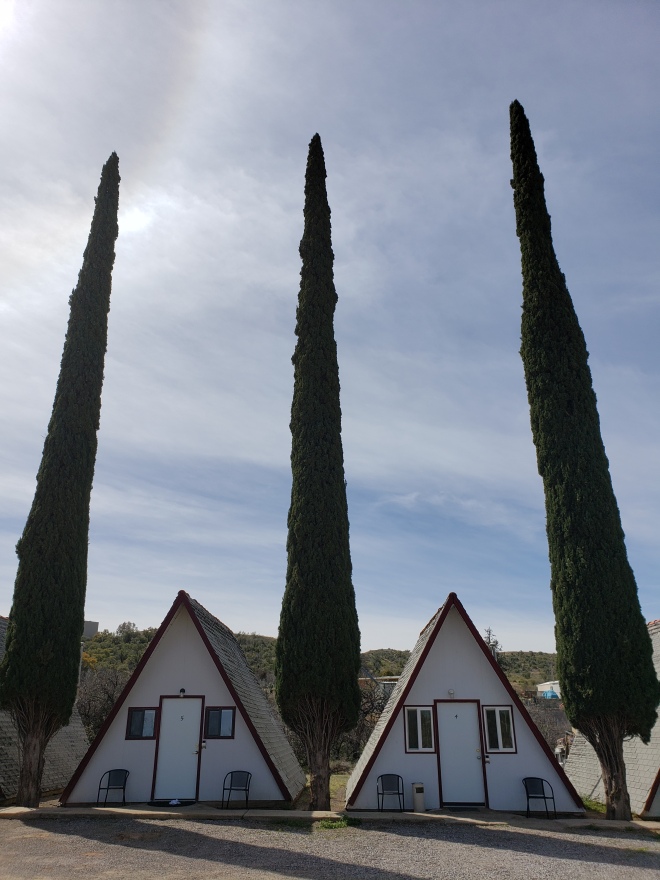
At her Village Motel Chalets, Marnie shows me where I can do laundry and use some loaner clothes. The hiker box is especially impressive, and I snag some shampoo, socks and a tin of Bag Balm that I intend to slather all over my tired feet.
The hot shower in my little A-frame chalet is pure bliss; dirt and caked on blood disappear down the drain. I lance a blister under my toenail, and borrow some flip flops and a t-shirt from the loaner box for a trip to the Circle K. Dinner is microwave burritos and some junk food that’s sure to do a number on my gut.
Back at my cabin, I watch outdated and horribly offensive westerns, as it’s the only channel that currently comes in on satellite. I’m too tired to give a shit though, and I massage my continuously swelling feet. Someone leaves two tall cans of Budweiser in the hiker box, so I’m sure to snag those up and pound them down before bed.
What a wild ride these first couple hundred miles have been. I came to Arizona to escape the snowy trails back home, only to have encountered even more snow. Yet, I still can’t wait to see what’s ahead.

Hi! Thanks so much for posting this. The AZT and CT are on my agenda for this year, and this is VERY helpful. You have some GREAT photos! What are you using to take them?
You had a BIG year! Congratulations on both of your hikes! :-). Have a great 2020 – and get some rest! LOL
LikeLike
Hi Lucy, thanks for reading!
I use the camera on my Samsung Galaxy s9+ to take photos.
I agree, it was a big year! Currently trying to get some much needed rest in between work & holiday stuff (thank goodness the latter is over, even tho it was enjoyable seeing my family).
More posts are coming soon, including a gear review. Cheers:)
LikeLike
Thanks!
LikeLike
Side note – I’m looking forward to hearing hour your gear worked out also. Thanks again….:-)
LikeLike