
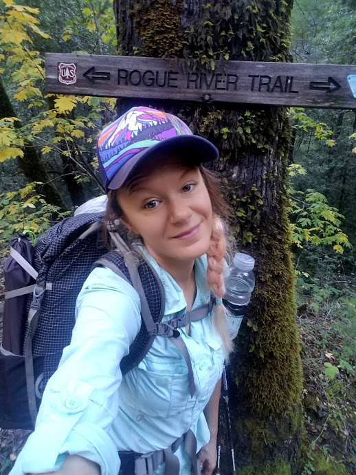
In need of one more long hike before winter brings down its frozen fury? Give the Rogue River Trail a go! Starting near Grants Pass in Oregon, the 40 mile path offers epic scenery, abundant wildlife and a gentle trail through the Rogue River canyon, eventually ending near the coast.

Rogue River Trail Journal
I had been eyeing a weather app on my phone for southern Oregon for two weeks prior to my hike on the Rogue, waiting in eager anticipation for a break in the gloomy October weather that had been plaguing the Pacific Northwest for a couple of weeks. I was dying to go on one last backpacking trip before the snow hit, but I feared I was too late. Some snow had already dumped in the Cascade Mountain Range near my home in the Snoqualmie Valley, making day hiking somewhat challenging. It’s not as if I’m not familiar with snow travel or route finding, it’s that I don’t always particularly enjoy it; especially when it’s the wet, sloppy snow that is common at the beginning and end of the season.
I had previously done a 10 mile section of the Rogue River Trail near Gold Beach a couple of years back, and I’ve been hopeful ever since that I could do it again in its entirety, from its trailhead at Grave Creek to its end at Foster Bar on the Oregon Coast. I got my break mid-week, when the weather forecast called for sunshine, no rain and (bonus) warm temperatures. It was supposed to be cold at night, but I could deal with it. As long as I didn’t have rain clouds obstructing my views, I was good to go.
My next challenge in planning my trip was transportation. If I had a companion ready to drop what they were doing to hike with me for a few days, then it wouldn’t be much of an issue. But this is the real world, and I often times have to fly solo (I’m 100% okay with this). The issue is this: As I’m starting and ending my trip at two different trailheads, I would need a ride either to or from one of those locations. Since my plan was to end at Foster Bar, an extremely remote location on a forest service road, hitching would be next to impossible. I would have to figure out a way from there back to my car parked at Grave Creek. If I was going with a friend, we could leave one car at the end and then drive to the start, no problem.
I found a solution thanks to some pretty amazing family members, who even have their very own trail angel names: Hummingbird and Magpie. They are recently retired, and were looking for a bit of adventure to fill their time. I mentioned the good weather on the way to the southern Oregon area, and they jumped at the opportunity to get out of town for a few days. They offered to drop me off at Grave Creek on their way to Ashland, then hop over to the coast for some scenic touring and pick me up a few days later. Brilliant.
(Thanks Hummingbird and Magpie!)
After a long, 8 hour drive from the Seattle area, we arrived at the Grave Creek trailhead late in the day on a Monday afternoon. I started the trail around 3pm, hoping to make it a few miles to the first campsite at Whiskey Creek, where there was a bear proof structure to store my food at night.
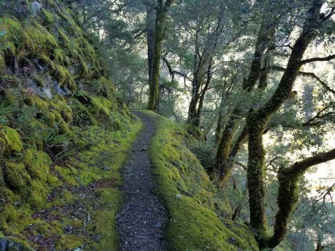
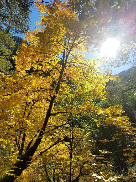
It was a warm day when I set out, and the trail climbed slightly away from the parking area at Grave Creek, following along side the Rogue River on a trail that has been cut into the side of the canyon wall. I waved goodbye to my family, and passed out of sight into the canyon. The scenery was already stunning; with eagle nests perched in the treetops above the river and autumn leaves washing the hillsides in golden colors.


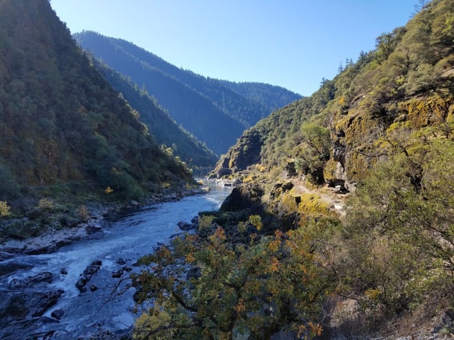


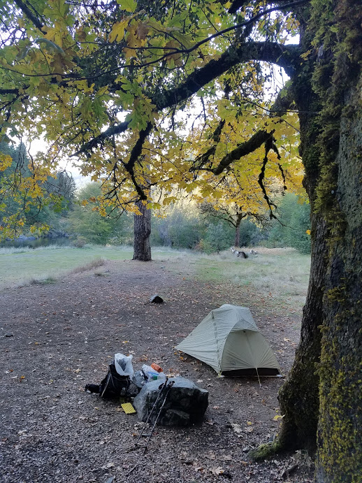
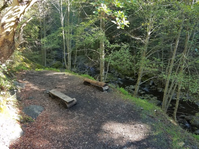
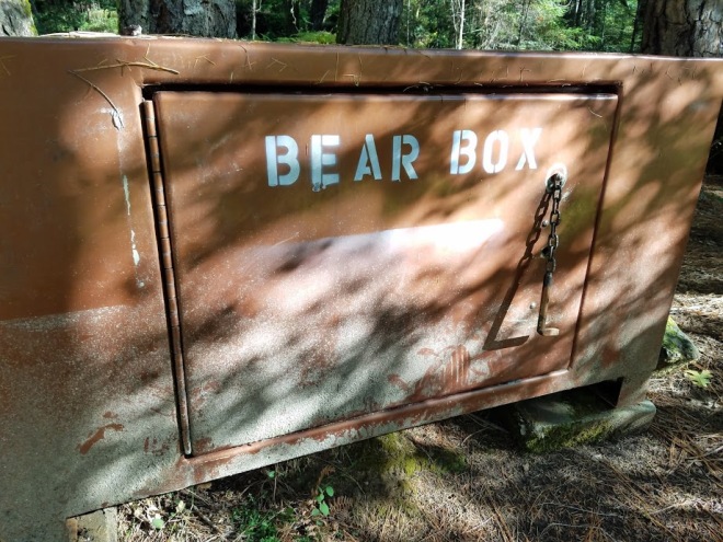
The sun quickly disappeared behind the towering peaks above the canyon, and the air cooled off almost immediately. The trail was rocky, but fairly easy-going, and I reached the established campsite at Whiskey Creek at just after 4pm. I considered going on, but the light was dull and I didn’t want to risk being caught walking in the dark before I reached the next campsite. I also wanted to take advantage of the bear proof food storage at the camp, which was a small enclosure guarded by an electric fence (this is so people fishing and boating on the river can store their coolers, but is still open for hiker use).
The camp itself was spacious, and directly on a large sandy area next to the river. I pitched my tent under a lovely flaxen oak, and went about cooking dinner and some hot chocolate. It was dead quiet, and a spooky mist started to rise from the river as it got dark. I put my food bag in the bear proof enclosure and enabled the electric fence, then headed to bed. Just as I was crawling into my tent, another hiker arrived to make camp, putting my creepy vibes at ease for the time being. I spent a couple of hours bundled up in my bag watching some Netflix series that I had downloaded to my phone (luxurious, I know) and trying to distract myself from the dark stillness outside.


I had some homemade porridge in the morning before breaking camp, and then set out pretty early. I wanted to do a long mileage day, hiking at least 20 miles before making camp again.
The day was peaceful and quiet, and the only other people I saw for the first few hours were those fishing from boats on the river. The trail remained high above the river for some time, dipping in and out of groves of madrone, oak and fragrant myrtle trees. A mist hung low in the canyon well into the morning, finally lifting when the sunshine began warming things up.


After a couple of hours, I passed a nice campsite along Bunker Creek, as well as the Black Bar Lodge, located on the opposite side of the river. I caught a few glances of the lodge through the trees, but mostly only knew it was there due to the sound of a generator running. The lodge is named after William Black, who was murdered in this location by his mining partner Dutch Henry, a scoundrel who killed him with an axe over a native woman. Dutch Henry (who was actually German) then placed the body of his slain partner in a boat and pushed it into the current, where it floated downriver. Oh, how the West is wild, am I right?
I stopped for lunch around Meadow Creek, the homestead area of the nefarious Dutch Henry, and filled up on water below the bridge. Just past the bridge was an enormous, wide open camping area for hikers overlooking the river, where I enjoyed my break. I noted how creepy it felt here, likely due to its dark history. After a nice lunch of cheesy crackers, beef stick and lots of chocolate, I pressed onward, racing the day.

By midday it was actually pretty hot on the exposed sections of the trail, and I looked forward to dipping back into the woods again and hiding beneath the cool shade. I passed by Battle Bar on the south bank, the location of combat between settlers and Native Americans during the Rogue River Indian Wars of 1855-1856. Further on, and quite a bit below me from the trail, is the site of Zane Grey’s cabin on Winkle Bar, who was a master author of the American West and wrote the well-known novel “Riders of the Purple Sage.” I didn’t go down to the cabin (although I wish I had) because I was pushing to do a 23 mile day and wanted to get to camp before nightfall. There is also a private residence down on the bar, and I didn’t want to intrude. Later, I found out that the cabin is open to the public.
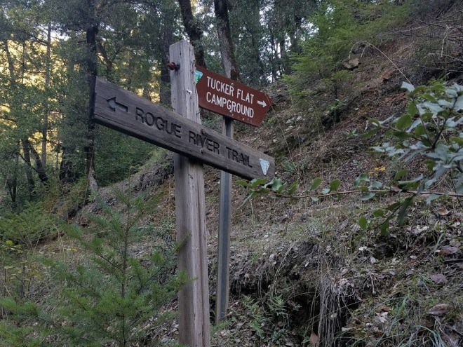
I reached the Rogue River Ranch at trail mile 22.7 in the early evening. The trail briefly skirts the property of the ranch, which is now a museum run by the Bureau of Land Management (built by settlers in 1903), and then abruptly ends and begins following a dirt road. The road had me going inland quite a bit, crossing Mule Creek via a bridge, and then passing a primitive public campground at Tucker Flat and the rustic Marial Lodge. The road is well way-marked, and becomes an actual footpath again at the Marial trailhead.


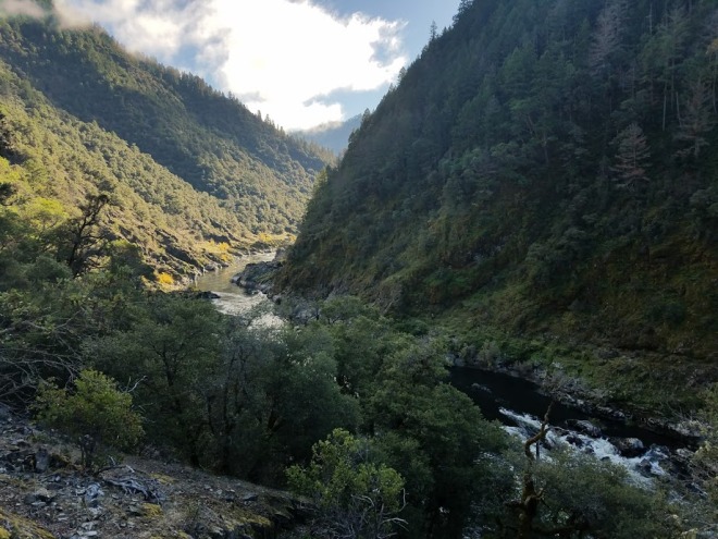
With my daylight fading, I manage to muster a second wind, although I’m pretty knackered at this point. The river has reappeared again, racing through a deep gorge and creating a thunderous sound that is echoing off the canyon walls. I meet two more hikers, the first I’ve seen all day. They, too, are planning on camping at Blossom Bar.
The sun is gone and the canyon is quite chilly when I arrive at camp. There’s a bear locker here, which I’m more than happy to utilize; the trail was littered with bear scat throughout the day, making it obvious the local bear population used the trail as much as any hikers. I filter some water from the nearby Blossom Bar Creek and go about fixing dinner, then get cozy in my bag.


I wake up when it’s still dark, wanting to get an early start and hit the trail once the daylight makes its first appearance. It’s incredibly cold, so I make a double batch of coffee and go about shaking the layer of frost from my tent (as well as shaking the ants that have invaded my food bag while it was in the bear locker overnight).
I spend the morning hiking through dark forest, passing another large camping area complete with a pit toilet. I consider using it, but am dissuaded by the strong and very unpleasant odor.
I reach the edge of the property for Paradise Lodge, and the trail takes me inland and away from the river again. As I’m skirting the perimeter of the property, a loud crashing in the bushes above me catches my attention. It’s a bear, and I see its rear end bounding away from me. I stop for a moment and strike my trekking poles together to scare it more, and suddenly the black, shadowy blob above me splits into three; two cubs scurry up a tree and mama whips around and grunts at me. I quietly take my leave, and hustle up the path.


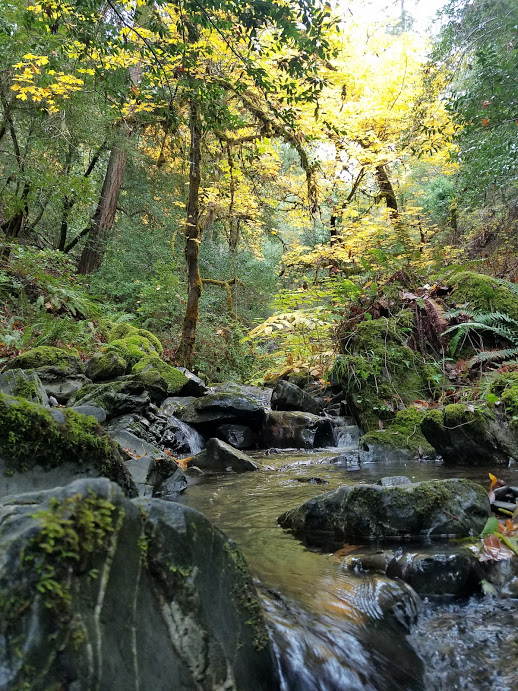
After a few more miles, the sun had warmed everything up again. In fact, it was downright hot outside, making the remainder of my hike a rather sweaty one (this is in October; weird). The trail alternates from an exposed, oak lined dusty path to a jungle-like environment in the gulches of the various streams, where everything is dripping with moss and dewdrops. Several areas of the trail have fallen victim to land slips and are covered by rocks, but they have been quickly rerouted by trail crews. I still used extreme caution in these areas, as the earth still seemed somewhat unstable in places.


I take a quick break at Tacoma Bar, where there’s a vast camping area for both hikers and boaters (as well as three different forms of food storage). Further on, I pass another fishing lodge at Clayhill and then reach the stunning waterfall near Flora Dell, where I pause for a moment to appreciate the scenery.
After Flora Dell, the trail splits into two options. I took the lower trail to the left, which I can only assume is the old trail. The upper trail is a possible a reroute from what appeared to be a mudslide on the original route. The trail I chose was fine; a bit overgrown and muddy in spots, but still easy enough to navigate. The map I downloaded indicated that there used to be a couple of creeks running down from the hillside, but the mudslide must have wiped them out some time ago. There was no water between Flora Dell and Billings Creek, unless one scrambles down to the river to retrieve it.


Once the two paths meet up again, I enter a grassy area shaded by lofty oaks and madrone trees. Out of curiosity, I check some of the long blades of grass that have been sweeping across my legs for the past 38 miles and make a menacing discovery: ticks, loads of them. Even with the extremely frigid nights, they have survived and were perched along the path looking for their next victims. Thankfully, I was wearing tights and long sleeves. I reach the Illahe Lodge around half past 1pm, and continue on towards the parking area at Big Bend. I nearly step on a turtle near Billings Creek, who is happily sunbathing in the trail. I snap a quick photo of the cute little guy, then cross the cow pasture to the lot.

I keep walking along the road, an additional mile or so, until I reach the boat launch and car park at Foster Bar. There, along the bank of the Rogue, is a small pumpkin to mark my finish of the trail; an appropriate end to an October backpacking trip! I give myself a thorough check for ticks, and am relieved to come up with empty handed. I fill out a bear report as I’m waiting for my ride to arrive, and eagerly eat the rest of my snacks.
Hummingbird and Magpie are early picking me up, and they come bearing an ice-cold orange Fanta and a bag of Cheetos (hell yes)! We make our way into Gold Beach, where a burger, fries and ice cream are calling my name.

Planning a Trip on the Rogue River Trail
Itineraries For a Rogue Adventure
Most people who hike the Rogue River Trail do so in the late Spring and Summer, and over the course of 4 or 5 days. My itinerary was more on the 2 to 3 day mark (almost 48 hours on trail), but I’m a pretty fast hiker. The trail is open year round; even in the winter it is accessible. I suggest doing it in the Autumn, as it gets crowded and really hot here in the summer. As I mentioned before, the weather was still warm and I got to experience quite a bit of solitude. Here’s a breakdown of my mileage over 3 days:
- Day 1: 3.2 miles, late start from the trailhead at Grave Creek. Camped at Whiskey Creek.
- Day 2: 23.7 miles, Whiskey Creek to Blossom Bar
- Day 3: 13.7 miles, Blossom Bar to boat launch at Foster Bar
I chose to camp in areas that had bear proof storage for food, and that was away from public areas for safety (since I was alone). I know that doing a 2 to 3 day itinerary can be beyond the comfort level of a lot of people, so here is a couple of suggested itineraries for those who wish to take more time hiking and possibly stop off at some of the historic sites along the way. Note that all itineraries are from Grave Creek, near Grants Pass, to Foster Bar, near Gold Beach (East to West).
4 Day Rogue River Trail Itinerary
- Day 1: Grave Creek to Horseshoe Bend, 11.4 miles and the campsite has an electric fence enclosure for food storage.
- Day 2: Horseshoe Bend to Tucker Flat Campground, 11.5 miles. Tucker Flat Campground is a free public campground accessible by car campers as well as hikers. There is no potable water here or food storage, but there is a pit toilet and picnic tables.
- Day 3: Tucker Flat Campground to Upper Solitude Bar, 8.3 miles. The campsite at Upper Solitude Bar is on the river, with an electric fence enclosure for food storage. There is also a pit toilet.
- Day 4: Upper Solitude Bar to Foster Bar, 9.4 miles
5 Day Rogue River Trail Itinerary
- Day 1: Grave Creek to Bunker Creek, 8.9 miles. There’s a small campsite on the other side of the bridge, with enough room for two small tents.
- Day 2: Bunker Creek to Ditch Creek, 7.4 miles. The campsite at Ditch Creek is very primitive, with no pit toilet and is only accessible by trail. It’s also fairly small, with two spaces that can maybe fit up to 3 small tents.
- Day 3: Ditch Creek to Blossom Bar, 10.2 miles. The camping at Blossom Bar is just past the bridge over Blossom Bar Creek. Get your water from the creek. There is a couple small places for tents near the bear locker, or a large space further down the trail for several tents.
- Day 4: Blossom Bar to Tacoma Bar, 6.2 miles. The campsite at Tacoma is enormous, and you’re likely to share it with boaters. There are 3 methods for storing food here: Bear locker, hoist and electric fence enclosure. There is also a pit toilet nearby.
- Day 5: Tacoma Bar to Foster Bar, 8.1 miles.
In the late spring, summer months and early autumn, it is possible to stay exclusively at the lodges along the trail instead of camping. This can obviously be costly, but if that’s more your thing then I’ll leave it up to you to do the research on where to stay. I’ve heard through the grapevine that reservations should be made well in advance, so keep that in mind when planning. If you really want to take the luxurious route, there are tour companies that will transport your luggage for you to the lodges your staying at, via jet boats on the Rogue. Again, likely a costly option. Here are the lodges along the way:
- Black Bar Lodge, mile 9.3, on the south bank. Reservations required, open May through early November. There is a footpath from the main trail down to the river, where you can arrange to be picked up by boat by the hosts. Website.
- Marial Lodge, mile 23.9. Reservations required, open May through early November. No website is available at time of print. Phone 541-474-2057.
- Paradise Lodge, mile 27.4. Reservations required, open May through early November. Meals included in prices. Website.
- Half Moon Bar Lodge, mile 28 and on the south bank. Reservations required. Website.
- Clay Hill Lodge, mile 33.2. Open May through November, reservations required.
- Illahe Lodge, mile 39. Reservations required, open year round. Meals included in price of stay. Website.

What to Pack
It goes without saying that you’ll need your usual backpacking gear for a trip on the Rogue River Trail, and assuming you have common sense, I don’t need to list everything that I think someone should take. Everyone is their own person, and different gear works for different people. If you’re interested in what gear I use, you can check out my gear list for the JMT here. I’m basically using the same gear, with the exception of a Ursack S29.3 for my food instead of the BearVault, and I switched my Big Agnes Fairview 2 person tent out for my Big Agnes Jackrabbit SL1 single person tent. I also did not take my Columbia wind jacket. This saved me an incredible 9 pounds 6 ounces in weight.
If you want to read a detailed review of my gear, then click here.
To make things easy, I’ve compiled a short, but sweet list of essential items for this particular trail, and for the time of year I’ve recommended going (Autumn). Here are my suggestions:
- Warm Sleep Clothes. I packed a long wool shirt, leggings, thick wool socks and a fleece lined beanie, and I’m sure glad I did. At one point, I even wore my puffy to bed. The Rogue River Canyon gets incredibly cold at night, so best be prepared. I woke up with a layer of frost on my tent one morning, as the condensation from the river and cold air settled in the canyon and then froze over.
- Toilet Tissue and a Trowel. There are several pit toilets along the way, but they all don’t have rolls of toilet paper, and the ones that did were quickly chewed to bits by the resident rodent population. Also, and I’m sure you’re quite aware of this, nature calls at inappropriate times. As in, when there’s no pit toilet in sight. Pack a trowel for digging catholes to poop in, and please please PLEASE, for the love of Mother Nature and the sake of the other hikers you’ll be sharing the trail with, practice Leave No Trace ethics when it comes to toilet paper and other hygiene products: pack it in, pack it out. Yes, that means putting your used sh*t tickets into a zip top bag and packing it out, or throwing it into the next pit toilet you encounter. Thank you, from myself and the squirrels.
- Long Pants and a Long Sleeve Shirt. As I mentioned before in my experience on the trail, there are ticks as late as October and despite the cold nights. Wear long pants and sleeves to protect yourself. Tuck your shirt into your pants, and your pants into your socks, no matter how nerdy this looks. If your canine friend is accompanying you, check them thoroughly and often. Learn how to remove ticks before you go.
- Sunscreen and a Brimmed Hat. If you choose to travel from East to West like I did, the sun will be at your back for most of the day. Several parts of the trail are rather exposed, and my neck turned a particular shade of red that will make the good ol’ boys back home envious. You won’t need much sunscreen, just enough to cover your neck or the backs of your legs for if you’ve ignored my advice about wearing long pants. A hat will help too, especially in the evenings when the sun is in the West and shining in your face.
Favorite Gear
I have a few pieces of gear that I consider “tried and true”, and I never go on a trip without them. Here they are:
- Dirty Girl Gaiters. I just recently replaced my first pair, which I used on thru-hikes of the Pacific Crest Trail, John Muir Trail, the West Highland Way in Scotland and the South West Coast Path in England. I love that they keep stones from entering my shoes. Also, that signature thru-hiker tan line above my ankles is pretty rad, I guess.
- Sawyer Squeeze Water Filter and Smartwater Bottle Duo. The Squeeze is small, light and efficient, and is compatible with a Smartwater bottle. The bottles are much easier to fill than the bags that are included with the filter, and even easier to replace if they fail. Clean it on a regular basis and it will last you several long distance trails.
- Patagonia Barely Bra. Soft on my “Grand Tetons” and just the right amount of support for hiking.
- Tenlab “Duece of Spades” Trowel. Weighs under an ounce and is an exceptional poop hole digging apparatus.
- Columbia PFG Bahama Long Sleeve Shirt. This is actually a shirt designed for fishing, but it is by far the best hiking shirt I’ve ever had. It keeps me cool when it’s hot, protects my skin from the sun, is efficient at blocking wind, and the front chest pockets are the perfect fit for my phone and a Clif Bar. Too bad it’s the color of toothpaste, but I scored this at a great price from a Columbia Outlet Store, so I really can’t complain that much.
- Darn Tough Vermont Medium Weight Crew Socks. There is no other greater sock, period. I very rarely get a blister with these socks, and they are crazy durable. Darn Tough stands by their product, so if you wear a hole in a pair, they’ll replace it for free. On trail, I rinse mine after a couple of days of use to get any grime out, then hang them to dry on the outside of my pack with a heavy-duty safety-pin as I hike. This will prevent them from wearing out too fast.
Nearly everything on this list can be purchased online at REI, with the exception of Dirty Girl Gaiters. Find those here.

Directions to the Trailheads
If your hiking with a partner or group, then leaving one car at Foster Bar/Big Bend on the Gold Beach side of the trail and then driving to the trailhead at Grave Creek will be much easier. There are a few different routes you can take out to Grave Creek, in which all are tedious and time-consuming (about a 4 hour drive). If you’re a solo hiker, then let’s hope you have good friends who can either pick you up or drop you off, or both.
Another, more expensive option, is to hire a tour company to drive your car from Grave Creek to Foster Bar, where it will be waiting for you when you’re finished with your trip. Just to warn you, they take your car on a route over unpaved forest service roads that often close when the weather is bad (like in the fall and winter). If this doesn’t bother you, then simply Google search “Rogue River car shuttle” and several companies who offer this service will come up.

Getting to Grave Creek Trailhead
On Southbound I-5 (from Portland): Take exit 76 toward Wolf Creek, continuing straight for a quarter mile on Old State Highway 99 South. Turn right onto Front Street, which becomes Lower Wolf Creek Road shortly after. After 5.6 miles, Lower Wolf Creek Road becomes Lower Grave Creek Road. Continue on for 9 miles, until you reach the large Grave Creek Bridge over the Rogue. Before the bridge, take a right and then an immediate left down into the parking area for the trail and boat ramp. It is important to note that there is no overnight parking here. If leaving a car overnight, you’ll have to park up on the side of the road and across the bridge.
Getting to Foster Bar or Big Bend Trailhead
From downtown Gold Beach, head north on Highway 101. Turn right onto County Road 595 (Jerry Flat Road). Take Forest Road 33 (Agness Road) 20.9 miles, then turn right onto County Road 375 (Agness Illahe Road) and go 3.4 miles to the Foster Bar boat ramp area. There is also a campground back here, with a year round camp host. I recommend leaving your car at the parking area at Foster Bar because of this. It’s definitely safer here with the constant presence of the host, than at Big Bend. The parking area at the Big Bend trailhead, where the Rogue River Trail either ends or begins for you, is much more secluded. Foster Bar is only a mile walk from Big Bend, and you can cut through the campground to avoid some road walking. Whatever you choose to do, it goes without saying that you shouldn’t leave anything valuable in your car.
More Helpful Info
The Forest Service has a nifty guide online that you can download straight to your smart phone, or print out the old-fashioned way. It’s a free PDF, and comes with a ton of useful information regarding the trail, the historical areas along the way and a handy map with mileage. You can find that here.
Things to Keep in Mind
- The trail is abundant in wildlife, this includes bears, rattlesnakes and mountain lions. Be “bear aware” at all times and store your food in the bear lockers or electric fence enclosures, or use the hoists. If these are not available, you’ll have to hang your food bag or pack in a bear canister. Remember, a fed bear is a dead bear.
- There is little to no potable water along the trail, so it’s up to you to filter or treat it for drinking. The Rogue River Ranch used to provide free drinking water to hikers, but as of publication there is a sign posted stating they will no longer do so until further notice. There is plenty of clear flowing creek water along the trail, so there’s little need to scramble down the precarious side paths down to the river.
- You do not need a permit to hike the Rogue River Trail, but you will need one for fishing. If that interest you, find more info here.
- Campfires within 400 feet of the river must be in a fire pan. Campfires can be banned at any time due to dry conditions and high winds. Check current regulations with the Smullin Visitor Center at 541-479-373 or the Gold Beach Ranger District at 541-247-360. Only build campfires in existing pits and practice Leave No Trace ethics.
- Watch out for poison oak along the trail, ticks in grassy areas and wasps and hornets nesting in the pit toilets.

Happy Trails, Rogue Hikers!
Hopefully with this post I’ve shed some light on a great location for a late season backpacking trip. I promise you, you’ll love it. As winter is just around the bend here in the PNW, I’ll be digging out my microspikes and down puffy, hitting up Mount Rainier for some snowshoeing, and pouring over maps and guidebooks in search of the next big trip. Stay tuned, and thanks for stopping by!
Until then, take a hike!
-Artemis☽


I’m looking for a good multi–night backpacking trip, and this looks amazing! I am a total wuss when it comes to bears though.
LikeLike
This is one of my most favorite trails! There are bear boxes and wires to store food in some campsites. I always stay at those ones.
LikeLike
Beautiful pictures. The NW is really special.
LikeLike
I love this write-up, thank you! I just googled “Is it safe to hike the Rogue River Trail alone?” and your post popped up. 🙂
I hiked the Oregon section of the PCT alone last summer, but this trail seems more remote (especially since I want to do it in October too), and I’m a little freaked out by rattlesnakes – even though I know they are probably the least of my worries. Thanks again – I’ll have to read your other posts too – happy to find your blog.
LikeLike